

Recomendados
Mais conteúdo relacionado
Mais de FAO
Mais de FAO (20)
Último
Último (20)
Global livestock densities
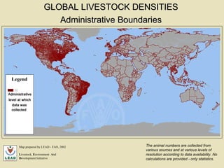
- 1. Administrative Boundaries Map prepared by LEAD - FAO, 2002 L ivestock, E nvironment A nd D evelopment Initiative The animal numbers are collected from various sources and at various levels of resolution according to data availability. No calculations are provided - only statistics. GLOBAL LIVESTOCK DENSITIES Legend
- 2. Small Ruminants Densities Legend GLOBAL LIVESTOCK DENSITIES Map prepared by LEAD - FAO, 2002 L ivestock, E nvironment A nd D evelopment Initiative
- 3. Poultry Densities Legend GLOBAL LIVESTOCK DENSITIES Map prepared by LEAD - FAO, 2002 L ivestock, E nvironment A nd D evelopment Initiative
- 4. Pig Densities Legend GLOBAL LIVESTOCK DENSITIES Map prepared by LEAD - FAO, 2002 L ivestock, E nvironment A nd D evelopment Initiative
- 5. Cattle Densities Legend GLOBAL LIVESTOCK DENSITIES Map prepared by LEAD - FAO, 2002 L ivestock, E nvironment A nd D evelopment Initiative