SlideShare uma empresa Scribd logo
1 de 16
Baixar para ler offline
continued on page 12
for Water & Wastewater Summer 2013
Esri News
Atlanta, Georgia, the ninth-largest metropoli-
tan area in the United States, has one of the
biggest and oldest water systems in the coun-
try. As such, the city delivers water to more
than one million customers through a network
of 2,700 miles of pipe. Three water treatment
plants (WTPs) serve the system. The service
area consists of three pressure zones. The
system includes water mains ranging from 2 to
72 inches in diameter, and some of the pipes
are 90 years old.
	 In a strategic effort to sustainably reha-
bilitate its aging system and increase system
control, the city decided to implement a
series of steps to fundamentally improve the
Department of Watershed Management’s
(DWM) infrastructure and work toward
Building Atlanta’s GIS
By Dax Flinn, City of Atlanta, Department of Watershed Management, and Ryan McKeon, Wachs Utility Services
integrating its GIS with its current legacy
and enterprise systems. To accomplish this,
DWM embarked on a series of major initia-
tives, which advanced the GIS program and
allowed it to provide a platform not only for
web-based viewing capabilities but also for
real-time field reporting and updating. To
achieve this goal, it first initiated an ambitious
and creative project in 2009 with the Valve
and Hydrant Asset Assessment Program.
Valve and Hydrant Asset
Assessment Program 2009–2012
For the first phase of this project, DWM
worked with Wachs Utility Services (WUS) and
Brindley Pieters & Associates and used ArcGIS
technology from Esri to focus on increasing
asset usability. This included the inventory,
repair, and documentation of 80,000 water
valves and fire hydrants in the system. This
first phase was completed in early 2012, and
while it was widely regarded as successful,
there remained an opportunity to increase in-
formation usability. Through 2012, the primary
information system of record was an atlas
of nonscaled plat card drawings. There had
been a previous effort in the 1990s to migrate
from paper to GIS, but data quality challenges
prevented the idea from gaining wide accept-
ance, and it eventually fell by the wayside.
	 To make full use of GPS and asset data
captured in the first phase of the project,
DWM commissioned a team of professionals
 The City of Atlanta’s web mapping application provides an easy way to view information.
2 Esri News for Water & Wastewater  Summer 2013
Summer 2013
Esri News for Water & Wastewater is a publication
of the Water/Wastewater Group of Esri.
To contact the Esri Desktop Order Center, call 1-800-447-9778
within the United States or 909-793-2853, ext. 1-1235, outside
the United States.
Visit the Esri website at esri.com.
View Esri News for Water & Wastewater online at 		
esri.com/waterwrites or scan the code below with your 		
smartphone.
Advertise with Us
E-mail ads@esri.com.
Submit Content
To submit articles for publication in Esri News for Water &	
Wastewater, contact Lori Armstrong, industry solutions
manager, at larmstrong@esri.com or Jessica Wyland, editor, at 	
jwyland@esri.com.
Manage Your Subscription
To update your mailing address or subscribe or unsubscribe to
Esri publications, visit esri.com/publications.
International customers should contact an Esri distributor to
manage their subscriptions.
For a directory of distributors, visit esri.com/distributors.
Circulation Services
For back issues, missed issues, and other circulation services,
e-mail requests@esri.com; call 909-793-2853, extension 2778;
or fax 909-798-0560.
Contents
Cover	
1	 Building Atlanta’s GIS
Case Study	
3	 Serving Customers with a Mobile Work Order System
5	 “If You Build It, They Will Become Aware”
8	 Mobile App Opens Customer Interaction
Partner Corner	
9	 Spatial Wave Software Benefits ArcGIS Users
10	 Securing Water Quality through Mobile Mapping
12	 Basic GIS Proves Innovative in a Developing Country
13	 Esri Online
13	 On the Road
14	 What Does the Esri UC Offer You?
The information contained in this work is the exclusive property of Esri or its licensors. This work is protected
under United States copyright law and other international copyright treaties and conventions. No part of this
work may be reproduced or transmitted in any form or by any means, electronic or mechanical, including
photocopying and recording, or by any information storage or retrieval system, except as expressly
permitted in writing by Esri. All requests should be sent to Attention: Contracts and Legal Services Manager,
Esri, 380 New York Street, Redlands, CA 92373-8100 USA.
The information contained in this work is subject to change without notice.
The Geographic Advantage, Esri, the Esri globe logo, 3D Analyst, ArcAtlas, ArcCatalog, ArcData, ArcDoc,
ArcEditor, ArcExplorer, ArcGIS, the ArcGIS logo, ArcGlobe, ArcIMS, ARC/INFO, ArcInfo, ArcLogistics, ArcMap,
ArcNetwork, ArcNews, ArcObjects, ArcPad, ArcPress, ArcReader, ArcSDE, ArcSurvey, ArcToolbox, ArcTools,
ArcUser, ArcView, ArcVoyager, ArcWatch, ArcWeb, ArcWorld, ArcXML, Business Analyst Online, BusinessMAP,
CommunityInfo, EDN, Geography Network, GIS Day, MapData, MapObjects, Maplex, MapStudio,
ModelBuilder, MOLE, NetEngine, RouteMAP, SDE, Sourcebook•America, StreetMap, Tapestry, @esri.com,
esri.com, arcgis.com, geographynetwork.com, gis.com, and gisday.com are trademarks, service marks, or
registered marks of Esri in the United States, the European Community, or certain other jurisdictions.
Other companies and products or services mentioned herein may be trademarks, service marks, or
registered marks of their respective mark owners.
Copyright © 2013 Esri.
All rights reserved.
Printed in the United States of America.
3Summer 2013  esri.com/waterwrites
Elsinore Valley Municipal Water District
(EVMWD) has provided water service in
California’s Riverside County for 55 years.
EVMWD covers a 96-square-mile area
along the Interstate 15 corridor and has
approximately 40,000 water, wastewater, and
agricultural services satisfying a population
of approximately 133,000. It is anticipated
that water demand will double within 10 years.
EVMWD employs 160 dedicated staff.
	 In 2009, EVMWD went live with a customer
information system (CIS). This robust system
was designed to handle a number of customer
service workflows including the issuing and
processing of service orders. Over the next
year, the district identified areas in which it
would like to improve the CIS workflow pro-
cess. For example, a service order (SO) would
be completed in the field and subsequently
processed back in the office.
	 At the time, the procedure was to generate
an SO in the CIS, then print it out and hand it
off to the field personnel who would cover a
designated area of the district. The field per-
sonnel would then fill out information on the
paper forms, and at the end of the day that
information would have to be reentered into
the CIS manually by a dedicated staff member.
This created a situation of duplicate data
entry. Another challenge faced was when new
service orders and updates came in through-
out the day, there was no easy mechanism to
get that information out to the field other than
a phone call or summoning the field staff back
into the office. With an area of 96 square miles,
this became a logistics nightmare.
	 “We are looking to save time by not having
to complete the service orders in the office
and instead completing them in the field,”
said Tammy Ramirez, meter services super-
intendent. “We need a mechanism to move
information out to the field and then back into
the CIS in a more streamlined manner.”
	 The goal now was to look for a commercial
off-the-shelf (COTS) mobile workflow solution
that would integrate with the CIS and solve
the aforementioned issues. The district also
Serving Customers with a Mobile Work
Order System
Elsinore Valley Municipal Water District Goes Paperless
By James A. Ollerton, Water Employee Services Authority
 Field Mapplet Mobile Highlighted Service Order
continued on page 4
Case Study
had interest in discovering a solution that
could satisfy additional criteria. The district
had a well-developed Esri-based GIS and
immediately realized the benefits of a solution
that would take advantage of the GIS data.
A computerized maintenance management
system (CMMS) was in place that was in need
of a GIS-based mobile component. The
district wanted a single mobile solution that
could address other field crew activity that did
not relate necessarily to the CIS or CMMS. As
can be seen from the criteria pattern so far,
it can be said that the district was looking to
support one mobile solution, thus reducing
the internal administrative challenges of sup-
porting multiple platforms. Finally, cost was
a key factor from a licensing standpoint, in
addition to the services involved, to do what
was needed.
	 EVMWD briefly considered the idea of
having the CIS accessible out in the field
through remote connection but quickly
rejected this idea due to a similar pilot effort
for remote connection of the CMMS. It was
decided from this pilot project that critical
workflow applications out in the field should
be able to perform in disconnected mode.
The district also was considering a mobile so-
lution sold as a separate module from the CIS.
It would satisfy the immediate need of the CIS
workflow issues but fell short of all the other
additional criteria. The district also looked
at other mobile platforms but was either not
impressed by the workflow architecture or felt
that the level of expertise was only in niche
workflows handled through the system and
would require major costs from an additional
consultant to make an integration successful.
	 Ultimately, EVMWD selected the Field
Mapplet solution from Spatial Wave.
EVMWD’s long history of involvement with
Esri’s Water/Wastewater group helped
the district learn of Spatial Wave. After
Spatial Wave had shown to the district the
solution and approach that it would take
4 Esri News for Water & Wastewater  Summer 2013
for integration, it was decided that this was
the right way to go. Another key factor that
played a role was the fact that the Field
Mapplet solution was GIS based and would
take advantage of the district’s mature
geodatabase. Another feature was the ability
to take advantage of ArcGIS web services and
the ability to execute ArcGIS geoprocessing
tasks.
	 “The GIS-based solution has helped in
areas where I didn’t even realize there could
be improvement; for example, the console
 Field Mapplet Mobile Highlighted Service
Order
 Service Order Summary Form in Field Mapplet
Serving Customers with a Mobile Work Order System  continued from page 3
is a good managing tool where I can gauge
work visually with the GIS map and reallocate
work as needed,” said Carol Mallard, billing
specialist.
	 Now, district field services representatives
have full access to the robust GIS database
and construction drawings. Ultimately, the GIS
solution enabled the field crews from both
CIS and operations departments to obtain
and perform their work in the field. Some of
the key capabilities of integration with CIS
included the following:
•• The exchange of information between CIS
Infinity and Field Mapplet was in real time.
Customer service requests will show up on
the mobile units after synchronizing the unit.
•• The process of creating service orders in
CIS Infinity passed the information to Field
Mapplet in order that a service request can
be created in Field Mapplet.
•• Service orders could now be delegated
easily by area of responsibility.
•• Mobile printer configuration allows printing
of labels and door hangers on the fly, out in
the field.
•• Route optimizing saves time and resources.
•• The process of completing service requests
in Field Mapplet passed information to CIS
in order that the service order can be com-
pleted and the meter info can be updated
in CIS.
In addition, EVMWD is taking full advantage
of all the other extensions of Field Mapplet
including valve exercising, advanced fire flow
testing, underground service alerts, redlines,
and soon-to-be-implemented sewer line
cleaning. Also, EVMWD anticipates soon
having the Field Mapplet mobile GIS solution
completely integrated with the CMMS. With
all this spatial metadata now being collected
and more to come, the district has wasted no
time in developing reports and GIS viewing
services that display the data in a manner that
only engages the staff better and helps them
understand more about what is going on at
the district.
	 GIS has enabled the district to implement
a unified mobile solution to process customer
service workflows, CMMS work orders, and
other field workflows, such as underground
service alert ticket processing, which are not
managed by these systems. In addition, Field
Mapplet has replaced the district’s hard-copy
facility atlas data with a robust electronic
mobile atlas while allowing for redlining of
the data. Combining Esri technology and the
Spatial Wave solution has resulted in optimiz-
ing district resource utilization while continu-
ously improving the quality of the GIS.
5Summer 2013  esri.com/waterwrites
Case Study
continued on page 6
It started as a free, public sewer infrastructure
map for Toms River, New Jersey. Len Bundra,
IT and GIS director for Toms River Municipal
Utilities Authority (TRMUA), built it in 2004.
Then, he kept adding layers. He added aerial
imagery, parcel data, and information from
agencies such as the New Jersey Department
of Transportation, the US Department of
Agriculture, and the US Census Bureau.
Bundra had one belief in mind: “If you build it,
they will become aware.”
	 He was right. When Hurricane Sandy
hit the East Coast of the United States in
October 2012, the map was suddenly the
go-to information source for emergency
responders, utilities, public works, private
surveyors, and local assessors. Bundra quickly
updated the map—known officially as the
Toms River Municipal Utilities Authority GIS
Map. He added poststorm satellite imagery
from the National Oceanic and Atmospheric
Administration (NOAA) along with current
floodplain delineations and Sandy high water
mark data from the Federal Emergency
Management Agency (FEMA).
“If You Build It, They Will Become Aware”
Integrated Web Map Aids Sandy Relief Efforts
By Jessica Wyland, Esri
 NOAA imagery for the Barrier Island areas of Toms River. Above shows before Sandy. Below
shows after Sandy.
	 Anyone who needed to quickly get an
accurate picture of the Sandy situation could
click the TRMUA GIS Map. Bundra built it,
and people did come. Police and fire fighters
came to determine where to deploy resources.
Electric, gas, and water companies came
to decide where to start restoring services.
Homeowners, evacuated and eager to survey
the damage to their property, came to look
at before-and-after aerial photos. And, as
Bundra predicted, people most definitely did
become aware.
	 “The map served as a valuable resource for
the police department after Sandy,” said Mike
Burke, IT and 911 coordinator for the Toms
6 Esri News for Water & Wastewater  Summer 2013
River Police Department. “We relied on that
visual representation—the before-and-after
layers—to set up security perimeters and
determine where to place cement barriers.”
	 Since the TRMUA GIS Map was built on the
Esri ArcGIS platform and hosted by Amazon
Web Services, it provides virtually unlimited
power for analysis, collaboration, and spatial
data processing. For example, following the
storm, many outside contractors arrived on the
shores of New Jersey to restore the region’s
infrastructure. One group in particular was
engineers who needed to figure out the best
plan for repaving roads. The TRMUA GIS Map
helped them find their way around unfamiliar
areas. They were able to use the map to locate
important elements such as parcels, street
addresses, hydrants, and underground utilities.
	 In the weeks and months following Sandy,
the map continued to help. Utilities used it to
review parcel polygons on the barrier islands
to identify houses and neighborhoods that
“If You Build It, They Will Become Aware” continued from page 5
	 Before Bundra created the map, Otten said
TRMUA engineers had to sift through a room
of drawers with thousands of engineering
drawings for information or request data from
other departments or agencies. Often, they
would have to send out crews for field visits.
Now everything they need is on the computer
screen with an aerial basemap. 
	 Otten says he can now view maps of all
430 miles of pipe, 9,600 manholes, and
18 pump stations, along with all attributes.
At a glance, he can see whether a pipe or
manhole has been inspected or rehabilitated
and then simply click to view an inspection
report or video. He can access various aerial
maps, including post-Hurricane Sandy and
aerial basemaps from as far back as 1930. He
can tell when a service lateral has been cut
were destroyed so those ratepayers would not
be charged for the year 2013. The map’s links
to FEMA flood advisory maps is helping af-
fected townships adopt a new flood insurance
risk map. Bundra also recently added a layer
to show houses that are slated for demoli-
tion and/or labeled uninhabitable to advise
citizens and utility companies on where to
focus rebuilding infrastructure.
	 For Bundra’s own company, the TRMUA
GIS Map continued to serve as a hub. “Simply
stated, the Toms River MUA GIS Map is a
comprehensive, one-stop shopping data-
base of all useful pieces of information for
everyone within TRMUA, as well as contrac-
tors, plumbers, consultants, and more,” said
Nicholas Otten, authority engineer for Toms
River Municipal Utilities Authority. “All various
pieces of data are centralized and accessible
by every TRMUA department within the office
or in the field.”
7Summer 2013  esri.com/waterwrites
and capped and see the triangulated location
sketch of the curb cleanout.
	 The map shows all billing information, in-
cluding the recorded number of fixtures within
a building. It also shows pump station data
and the number of connections flowing to the
station, hundreds of pages of data on emer-
gency generators, wiring diagrams, pertinent
engineering drawings, and pump curves.
“With a few clicks, I am also able to generate
specific reports,” Otten said. “With GIS, I can
determine the approximate, average flow within
any given pipe segment. I can list pipes and
manholes by name. I can find the names and
mailing addresses of property owners within
200 feet of one of our construction projects.”
History of GIS at TRMUA
TRMUA began its GIS work in 2005 in an effort
to assemble 40 years of paper plans and files
into a centralized mapping interface. The
system was built entirely by in-house staff,
without the use of any outside consultants,
and was completed within two years.
	 All 9,600 of TRMUA’s sewer manholes had
exact coordinates verified in the field using
submeter GPS units. More than 600,000 line
and manhole attributes were entered into
an Esri geodatabase from more than 3,000
engineering plans.
	 In addition, an entire GIS parcel basemap
was created from scratch to include additional
elements not typically found on the tax maps.
For example, 3,000 individual condo units and
all major apartment buildings were added to
the basemap, which was then aligned to New
Jersey State US Geological Survey (USGS)
orthophotography.
	 The system is now available for all TRMUA
office staff across an internal network and to
all field staff via ruggedized laptop units. 
“The GIS has increased operational efficiencies
across all departments by allowing instanta-
neous access to data that previously had to
be searched for amongst reams of paper files
and plans,” Bundra said. “The GIS also allows
our field crews access to all the information
they need to quickly assess and properly ad-
dress emergency situations.”
 There are 2,558 points hyperlinked to post-
Sandy aerial oblique photographs from Civil
Air Patrol added to the TRMUA GIS Map.
Case Study
8 Esri News for Water & Wastewater  Summer 2013
The Washington Suburban Sanitary Commission (WSSC), headquar-
tered in Laurel, Maryland, recently used Esri technology to develop a
mobile application where customers can pay bills, report out­ages, and
check the status of a service request. The mobile solution increased
customer satisfaction by providing functionality 24/7 via iPhone,
Android, or BlackBerry smartphones.
	 Customers can use WSSC Mobile to pay all or a portion of their
bill, view bill and payment history, purchase watershed use permits,
and see a historical graph of actual household water consumption.
Customers can also report problems immediately to WSSC staff and
check for updates on service alerts in their area.
	 Established in 1918, WSSC is among the largest water and waste-
water utilities in the nation, with a network of nearly 5,600 miles of
freshwater pipeline and more than 5,400 miles of sewer pipeline. The
company serves 1.8 million residents through approximately 460,000
customer accounts. WSSC drinking water has always met or exceeded
federal standards. WSSC operates and maintains three reservoirs, two
water filtration plants, and six wastewater treatment plants.
	 “We needed a more efficient way to interact with customers without
tying them to desktop computers,” said Mujib Lodhi, chief information
officer for WSSC. “We also saw an opportunity to improve service and
repair operations using data gathered by customers’ mobile devices.”
	 The ability to report an outage—complete with location informa-
tion and images—is particularly useful to WSSC. It potentially adds
1.8 million pairs of eyes, those
of the customer base, to help
monitor nearly 11,000 miles of
water and wastewater system
infrastructure.
	 Within the customer contact
center, Lodhi said they anticipate
reductions in call volume and
call-handling times, as well as
the near elimina­tion of the rou-
tine customer requests that can
be more easily handled through
the mobile application.
	 Quicker incident reporting
will lead to faster repairs, dol-
lars saved, and better service
for the community when it
comes to water incidents and
emergencies.
	 To build the mobile app,
WSSC used its existing industry-
standard web and Esri ArcGIS ar-
chitecture, the IBM WebSphere
suite for all Java 2 Enterprise
Edition (J2EE) applications, and
Oracle for the relational data-
base man­agement system.
Mobile App Opens Customer Interaction
Washington Suburban Sanitary Commission
 Using the WSSC mobile application, customers
can pay bills, report outages, and check the
status of a service request.
9Summer 2013  esri.com/waterwrites
Partner Corner
Spatial Wave Software delivers high-quality,
innovative, GIS-based software products for
those seeking to maximize their investment
in ArcGIS from Esri. Spatial Wave Software
was formerly the products division of DCSE, a
California-based engineering and GIS consult-
ing firm, and has been an Esri partner since
1996. Spatial Wave products are designed
based on over 25 years of GIS experience
delivering solutions to water and wastewater
utilities.
	 The Spatial Wave product family includes
Mapplet, a robust workflow and operations
dashboard; Field Mapplet, a mobile workflow
solution; and Mapplet Library, a GIS-based
map and document management system.
Each of these solutions has the ability to work
independently of each other.
	 Field Mapplet is specially designed to
manage any workflow that spans office and
field, including underground service alerts,
work orders, customer service requests, peri-
odic monitoring, and inspections. MP/USA is
a configuration of Field Mapplet supporting
a utility’s one-call process. Field Mapplet
easily integrates with an organization’s tabular,
document, and Esri data environments.
	 Mapplet enables users across the enter-
prise to gain access to data and documents
from a spatial perspective. Mapplet is
integrated with ArcGIS API for Silverlight from
Esri. It allows you to gain access to data from
all aspects of your organization, including cus-
tomer service, field operations, engineering,
and finance, and any other enterprise data to
which you wish to connect.
	 Mapplet Library is a web-based application
for distributed sharing of thematic ArcGIS
maps. Mapplet Library has been deployed at
numerous water districts to make it easier to
find and view large libraries of maps already
Spatial Wave Software Benefits ArcGIS Users
created by multiple departments. It reduces
the tech­nical proficiency needed and in-
creases the audience within your organization
who can benefit from GIS assets. In fact, in
the early days of Mapplet Library, thousands
of Esri International User Conference (Esri UC)
attendees were using the application at the
Map Gallery to submit and retrieve entries for
the Map Gallery competition.
	 Spatial Wave is a single vendor with exten-
sive experience providing proven, integrated
solutions and services for water and wastewater
utilities. Spatial Wave is known for providing a
cost-effective solution suite that is easy to use,
proven, efficient, and cost-effective to maintain.
Spatial Wave understands the needs of water
and wastewater agencies, anticipates the future
needs of a district, provides additional solutions,
and scales with each client’s needs.
Visit www.spatialwave.com.
 GIS Platform and Powerful Organization Viewer
 GIS for Spatially Enabled Workflows
 Mobile Solutions for Utility Field Crews
10 Esri News for Water & Wastewater  Summer 2013
Residents of Collingwood in southern Ontario,
Canada, can rest assured that the water
distribution system they depend on is in good
hands thanks to a unique mobile application.
Developed using ArcGIS, the app supports
effective fire hydrant flushing throughout the
town—a central component to delivering
clean water.
	 Fire hydrant flushing is one of the most
important practices that can be performed on
a water distribution system and provides an
opportunity to check for leaks, proper valve
operation, corrosion and rust, water pressure,
and chlorine levels. If ignored, corrosion and
rust can cause serious public safety concerns,
not to mention threats to water quality.
	 In the town of Collingwood, fire hydrant
maintenance is carried out by Collingwood
Public Utilities/COLLUS Power, a municipally
owned utility that provides both water and
electricity services. With a commitment to
continuous improvement through innovative
business processes and technology, COLLUS
signed an enterprise license agreement (ELA)
with Esri Canada Limited so that it could cost-
effectively deploy multiple licenses of ArcGIS
and integrate the software into the weekly
and annual flushing program.
	 “Our field operations have rapidly evolved,”
said Jody Wilson, GIS technician, COLLUS.
“We’ve expanded from a few licenses to
running ArcGIS in 12 of our trucks. As a result,
we’re operating more productively, and our
ability to capture accurate data has grown by
leaps and bounds.”
	 Each week, operators flush out what’s
known as “dead end” hydrants—hydrants
located at the end of a street that receive
water from a single direction. These hydrants
must be checked on a regular basis to ensure
“We’re working more efficiently and are much better
equipped to demonstrate compliance. Our reports are
no longer based on assumptions. Through GIS, we’re
able to ensure complete accuracy when audited.”
—Jody Wilson, COLLUS
Securing Water Quality
through Mobile Mapping
By Barry Kelly, Esri Canada Limited
that they are fully functional and that chlorine
levels are in line with government standards.
	 Flushing the hydrants involves opening one
of the three ports of the hydrant and allowing
the water to flow wide open. Crews check
for ease of opening and closing, ensure that
water flow stops when the hydrant is shut
down, and check to see if remaining water
drains down below ground level into the sur-
rounding soil. If a hydrant does not perform
all these functions with ease, the hydrant is
flagged for repair.
	 To record results, operators use GPS-
enabled ruggedized mobile units that provide
access to basemaps; orthoimagery; and layers
of data such as parcels, property boundaries,
parks, and streets. When conducting a flush,
a new task is opened in ArcGIS, and the
operator fills out a series of attributes that
are pulled from the utility’s main database.
Attributes include the operator’s name, the
date of the flush, current chlorine levels, the
amount of water flushed, and the hydrant’s
pounds per square inch (PSI).
	 A user-friendly touch screen makes it quick
and easy to record the results of the inspec-
tion and move on to the next hydrant. Once
the operator returns to the office and is within
wireless range, all the new data is instantly
synced back to the main database.
	 Then models created using ArcGIS enable
data to be automatically calculated. For exam-
ple, the amount of waste resulting from a flush
can be instantly generated and included in
reports required for annual audits.
	 “We’re working more efficiently and are
much better equipped to demonstrate
compliance,” said Wilson. “Our reports are
no longer based on assumptions. Through
GIS, we’re able to report on exactly how many
hydrants were flushed, for what length of
time, as well as the volume of water flushed to
ensure complete accuracy when audited.”
	 In addition to weekly dead-end flushes,
COLLUS is responsible for conducting a bian-
nual inspection of the town’s 1,200 hydrants.
GIS is used to keep an up-to-date inventory of
the hydrants and analyze each asset’s history.
To carry out the biannual flushes, four trucks
are dispatched to different areas of the town.
Through shared access to the data, all four
11Summer 2013  esri.com/waterwrites
operators can ensure that no hydrants are
missed during the inspection. When an asset
is identified as in need of repair, operators
mark this on the attribute form, and a call for
service is placed immediately.
	 Previously, operators would record data
by creating hand-drawn checklists in Excel
spreadsheets. The sheets would then be
stapled together, placed in a binder, and used
during the annual audit. Using this system,
the utility was not able to automatically call
up data, perform calculations, or analyze the
asset’s history.
	 “We can now pull up a five- to six-year his-
tory of a hydrant and proactively troubleshoot
any potential issues pertaining to that asset,”
said Wilson. “For example, if we receive a
complaint from a resident regarding a water
issue, we’re able to instantly view nearby
hydrants, check the condition, and see the
date of the last flush to get to the root of the
problem.”
	 In the near future, COLLUS will look at ex-
tending GIS capabilities to Apple and Android
devices so that operators in the field will be able
to capture data using smartphones or tablets.
Visit esricanada.com.
 The Identify tool in ArcGIS is used on a
recently added hydrant inspection. The
Identify Results window shows inspections
dating back to 2007, which can be individually
selected and viewed by operators in the field.
Partner Corner
12 Esri News for Water & Wastewater  Summer 2013
Basic GIS Proves Innovative
in a Developing Country
By Rochelle Holm, Washington State University
 Shallow well water
quality results from
Mzuzu, Malawi, are
plotted using ArcGIS.
On a recent rainy day, researchers were
huddled in a small laboratory in the Central
African country of Malawi, conducting water
quality analysis with onlookers eager for GIS
maps depicting the results. Few individuals
in Malawi are trained in GIS skills, and within
the university setting, GIS theory, rather than
practical application, is the standard.
	 In January 2012, a laboratory for water
quality testing was established at the
Mzuzu University Centre for Water and
Sanitation, Malawi, through a partnership with
Washington State University in the United
States. In Malawi, university attendance is
only 0.6 percent of the population, limiting
trained personnel in the water and sanita-
tion sector and those with GIS skills. In many
areas of Malawi, the risk to human health from
microbial drinking water contamination is not
known. This lack of data poses a unique chal-
lenge for governmental and nongovernmental
agencies working to protect human health
and the environment.
	 Basic skills in Esri’s ArcGIS technology were
recently used in combination with a water
quality investigation conducted in Mzuzu
in northern Malawi. Although the area has
municipal piped water service, shallow wells
are still used for drinking by some households.
ArcGIS provided a powerful and innovative
tool to visually depict the results of this
investigation as part of a risk communication
program. Results were reported back to
individual households at the conclusion of
the project as part of a targeted risk com-
munication program in an effort to encourage
behaviors that protect both human health and
the environment in this developing country.
Building Atlanta’s GIS  continued from cover
to construct a water utility GIS. This phase of
the project focused on the consolidation of
data spread across 7,000 plat card drawings,
hundreds of thousands of inspection records,
and 80,000 GPS data points into a spatially
accurate, content rich, and widely available GIS.
	 In addition, DWM employed GIS to support
water network hydraulic modeling initiatives,
operations and maintenance activities, and
capital improvement planning.
	 The Valve and Hydrant Asset Assessment
Program named two key objectives: restore
Atlanta’s water distribution system of approxi-
mately 48,000 valves and 24,000 fire hydrants
to maximum operability, and develop a
GIS database with necessary water system
transmission and distribution asset records
and GPS locations to meet water utility asset
management and maintenance requirements.
 Shallow well data collection is performed.
	 Phase I began in 2009. With a three-month
time limit, the team began preparing a base
of operations at the Peyton Road DWM Pipe
Yard. This included permitting, preparation of
the yard, procuring equipment, building ser-
vice trucks, setting up the computer network,
and all internal processes.
	 Phase II began during the final days of setup
at Peyton Road. Field Services included the
core scope of the primary objective to assess
48,000 valves and 24,000 hydrants and com-
plete in-scope repairs on valves. During these
assessments and repairs, more than 100 pieces
of data were collected on each asset, including
the GPS location. This data was compiled and
analyzed scrupulously to meet the needs of the
utility to complete a functioning GIS.
	 To reach assessment and repair goals, the
city first worked on pilot areas, then focused
on places where the hydrant flow was not per
the minimum standard.
	 By January 2012, the information services
team was delivering data on a weekly basis.
The first delivery of 12,511 assets and each
subsequent delivery only contained assets
that had gone through the entire assess-
ment cycle. This means that each valve and
hydrant in the delivery was exercised, made
accessible, repaired if necessary, and had its
GPS points logged. Furthermore, each piece
of data has gone through QA/QC and GIS
processes to ensure accurate information and
location for the asset.
	 Phase III began in April 2012 and included
utilizing the information for the valves and
hydrants collected under the Valve and
Hydrant Asset Assessment Program; the
group would create the geometric network
Mark Your Calendar
Esri International User Conference
July 8–12, 2013
San Diego, CA USA
www.esri.com/events/user-conference
National Rural Water Association H2O XPO
October 1–3, 2013
Louisville, KY USA
www.h2o-xpo.org
Water Environment Federation Technical Exhibition and
Conference (WEFTEC)
October 5–9, 2013
Chicago, IL USA
www.weftec.org
Pollutec Horizons
December 3–6, 2013
Paris, France
www.pollutec.com/GB.htm
On the Road
13Summer 2013  esri.com/waterwrites
Follow the Esri Water Community on Twitter
Keep up with the latest GIS news, especially as it relates to the
water industry, by following Esri on Twitter:
@esriteamwater
Watch Recorded Webinars
Visit esri.com/water and look under Announcements for new
webinars including Hydraulic Modeling and GIS and Services and
Solutions for the Water Utility Industry.
Access for Water Utilities
This website is for the ArcGIS water, wastewater, and storm water
utility community. It provides useful templates and best practice in-
formation enabling you to implement ArcGIS to manage your water
utility information, perform your daily operations, and support your
long-term planning.
Visit resources.arcgis.com/content/water-utilities.
Esri Onlinedepicting the pipes that connect the valves and hydrants together in a
functioning hydraulic network. This data, in conjunction with the DWM
plat cards showing pipe connections and relative pipe locations, was
used to build a geometric network for modeling the flow of water in
the water transmission and distribution system. Phase III was success-
fully completed in December 2012.
	 By the end of the project, the team had surpassed its goal by assess-
ing its targeted valves and hydrants on time, updated and vastly im-
proved the water distribution system GIS, and come in under budget.
Additional Benefits
Hospital Corridor
The city of Atlanta was in the process of replacing a bridge at
Peachtree-Dunwoody Road. Along that bridge is a main that
feeds seven hospitals. In the event that the main was disturbed,
the team wanted to be proactive and make sure there was a
secondary feed. It redirected a crew to locate certain valves that,
if necessary, could create a new zone to feed the hospitals. A crew
spent 1.5 days locating and making accessible seven valves along
the hospital corridor in Sandy Springs. Now, should there be a
disruption, the city can immediately execute the rezoning plans.
North Treatment Plant
The North Treatment Plant located in Johns Creek has a 48-foot
transmission main running 12 miles that feeds the city. A valve
replacement stopped treatment plant pumping for 24 hours. This
provided a perfect time to exercise valves along the main.
	 To take advantage of the downtime, a crew was sent out to
locate and identify all the city’s valves along the main. Making a
trip prior to shutdown allowed all the valves to be exercised in
a short period of time. Searching through woods and along the
400 Toll Road, 12 of 15 valves were located and made accessible.
The remaining three could not be found because of poor loca-
tion data. The team exhausted all standard locating techniques,
including the use of ground penetrating radar, in an extensive
search to find the last three. Instead, GPS was used to pinpoint
the area where the team believed them to be.
More Advancements
With the support of the executive offices within DWM, the GIS
Division has implemented a migration of the GIS datasets to
the ArcGIS Local Government Information Model; introduced
ArcGIS for Windows Mobile; purchased new data servers and
updated major application components; built a new web mapping
application called the Atlanta Land Information System (ATLIS);
integrated GIS and electronic documents and files with the DWM
Electronic Content Management System (ECMS); and is looking to
ArcGIS Online and its local government integration capabilities by
moving toward smartphones and tablets for increased integra-
tion of field reporting, viewing, and communication. It has been
an ambitious road, and the benefits can be seen by the wealth of
information now available to the department.
14 Esri News for Water & Wastewater  Summer 2013
This year, the Esri International User
Conference (Esri UC) promises inspiration,
collaboration, and practical application for
water, wastewater, and stormwater profession-
als. This conference will provide an opportu-
nity to be surrounded by thousands of fellow
GIS professionals who have found innovative
solutions to common challenges.
	 Plan to attend the following moderated
paper presentations and technical workshops
designed specifically for water, wastewater,
and stormwater professionals:
•• ArcGIS Online for Water, Wastewater, and
Stormwater
•• Enterprise GIS
•• Getting the Most Out of Your Assets
•• GIS Tools for Stormwater Billing
•• GIS Implementation
What Does the Esri UC Offer You?
•• GIS for Stormwater Management
•• Web Technologies for Water
•• Water Modeling and GIS
•• Innovations in Water GIS
•• GIS and Asset Management
•• Using GIS for Field Operations
•• GIS for Wastewater
•• SCADA and GIS
Check out the Team Water/Wastewater/
Stormwater Meeting scheduled for
Saturday, July 6. And, be sure to attend the
Special Interest Group Meeting at noon
on Wednesday, July 10. Plus, the annual Pool
Party will be held at the Hilton San Diego
Bayfront at 7:00 p.m., Wednesday, July 10.
	 During the Esri UC, you’ll be able to visit
the Solutions Island in the GIS Solutions EXPO
to speak with Esri experts about ArcGIS for
water utilities.
	 Participate in the Water Utility Data
Health Checks each day of the Esri UC.
Schedule a 45-minute review and analysis of
your data from Esri’s water utility experts. In
addition to examining data accuracy, they will
use ArcGIS Data Reviewer for Desktop to run
diagnostics and evaluate overall data quality.
If you maintain parcel data, they will also be
able to assess whether or not it is ready to be
loaded into the parcel fabric. To schedule an
appointment, e-mail datareviewer
@esri.com with your name, organization, con-
tact information, and preferred date and time.
For more Esri UC info, visit
esri.com/uc.
Esri International User Conference
You are GIS.
You gain knowledge, share expertise, and help us understand our world.
There’s a place where GIS goes beyond coordinates, breaks free of categories,
and reaches past analysis. A place where products are launched, ideas are
shared, and inspiration is set loose.
Join us at the Esri UC. Register today at esri.com/ucwater.
United we map!
Esri International User Conference
July 8–12, 2013 | San Diego Convention Center
Copyright © 2013 Esri. All rights reserved.
15Summer 2013  esri.com/waterwrites
Full Page ad
to come
Presorted
Standard
US Postage
Paid
Esri
380 New York Street
Redlands, California 92373-8100  usa
135661  xxxxx6/13sp
30-day free trial: esri.com/agol
Creating your own map from maps published by other users is just one of many ways to take
advantage of the rich collection of data and resources ArcGIS
SM
Online makes available to you.
Welcome to the new frontier in geographic information systems.
ArcGIS Online
Copyright © 2012 Esri. All rights reserved.
30-day free trial: esri.com/agol
Creating your own map from maps published by other users is just one of many ways to take
advantage of the rich collection of data and resources ArcGIS
SM
Online makes available to you.
Welcome to the new frontier in geographic information systems.
ArcGIS Online
Maps made better.
(Some assembly required.)
Copyright © 2012 Esri. All rights reserved.

Mais conteúdo relacionado

Mais procurados

Spring 2013
Spring 2013Spring 2013
Spring 2013Esri
 
Esri News for State and Local Government Spring 2013 issue
Esri News for State and Local Government Spring 2013 issueEsri News for State and Local Government Spring 2013 issue
Esri News for State and Local Government Spring 2013 issueEsri
 
ArcGIS as a Platform
ArcGIS as a PlatformArcGIS as a Platform
ArcGIS as a PlatformGovLoop
 
Arc news - Fall-2015
Arc news - Fall-2015Arc news - Fall-2015
Arc news - Fall-2015what3words
 
Esri News for State & Local Government newsletter
Esri News for State & Local Government newsletterEsri News for State & Local Government newsletter
Esri News for State & Local Government newsletterEsri
 
Web Mapping - exploiting location based information through eGovernment
Web Mapping - exploiting  location based information through eGovernmentWeb Mapping - exploiting  location based information through eGovernment
Web Mapping - exploiting location based information through eGovernmentDavid Hayward
 
The Mapping Revolution: Incorporating Geographic Information Systems in Gover...
The Mapping Revolution: Incorporating Geographic Information Systems in Gover...The Mapping Revolution: Incorporating Geographic Information Systems in Gover...
The Mapping Revolution: Incorporating Geographic Information Systems in Gover...GovLoop
 
SSMIC ESRI Case Study 2010
SSMIC ESRI Case Study 2010SSMIC ESRI Case Study 2010
SSMIC ESRI Case Study 2010steering
 
Tracking the Anonymous GIS User in King County
Tracking the Anonymous GIS User in King CountyTracking the Anonymous GIS User in King County
Tracking the Anonymous GIS User in King CountyGreg Babinski
 
Multi Layer GIS Platform in Digital India - Mr. Vishnu Chandra
Multi Layer GIS Platform in Digital India - Mr. Vishnu ChandraMulti Layer GIS Platform in Digital India - Mr. Vishnu Chandra
Multi Layer GIS Platform in Digital India - Mr. Vishnu ChandraNeGD Capacity Building
 
Climate Change & Africa
Climate Change & AfricaClimate Change & Africa
Climate Change & AfricaEsri
 
Improving Citizen Engagement: Gov 2.0
Improving Citizen Engagement: Gov 2.0Improving Citizen Engagement: Gov 2.0
Improving Citizen Engagement: Gov 2.0Esri
 
Richland_County_JMG_Award_Application_2016
Richland_County_JMG_Award_Application_2016Richland_County_JMG_Award_Application_2016
Richland_County_JMG_Award_Application_2016Patrick Bresnahan
 
Doron REU Final Paper
Doron REU Final PaperDoron REU Final Paper
Doron REU Final PaperMa'ayan Doron
 
Geospatial solutions for creating a smart city
Geospatial solutions for creating a smart cityGeospatial solutions for creating a smart city
Geospatial solutions for creating a smart cityShristi Paudel
 
Location analytics-put-the-where
Location analytics-put-the-whereLocation analytics-put-the-where
Location analytics-put-the-whereEsri
 
UGIC 2009 Conference
UGIC 2009 ConferenceUGIC 2009 Conference
UGIC 2009 ConferenceWansoo Im
 

Mais procurados (20)

Spring 2013
Spring 2013Spring 2013
Spring 2013
 
Esri News for State and Local Government Spring 2013 issue
Esri News for State and Local Government Spring 2013 issueEsri News for State and Local Government Spring 2013 issue
Esri News for State and Local Government Spring 2013 issue
 
ArcGIS as a Platform
ArcGIS as a PlatformArcGIS as a Platform
ArcGIS as a Platform
 
Arc news - Fall-2015
Arc news - Fall-2015Arc news - Fall-2015
Arc news - Fall-2015
 
Utah Reorganizes its GIS Around Web Services
Utah Reorganizes its GIS Around Web ServicesUtah Reorganizes its GIS Around Web Services
Utah Reorganizes its GIS Around Web Services
 
GIS in Utah
GIS in UtahGIS in Utah
GIS in Utah
 
Esri News for State & Local Government newsletter
Esri News for State & Local Government newsletterEsri News for State & Local Government newsletter
Esri News for State & Local Government newsletter
 
Web Mapping - exploiting location based information through eGovernment
Web Mapping - exploiting  location based information through eGovernmentWeb Mapping - exploiting  location based information through eGovernment
Web Mapping - exploiting location based information through eGovernment
 
The Mapping Revolution: Incorporating Geographic Information Systems in Gover...
The Mapping Revolution: Incorporating Geographic Information Systems in Gover...The Mapping Revolution: Incorporating Geographic Information Systems in Gover...
The Mapping Revolution: Incorporating Geographic Information Systems in Gover...
 
SSMIC ESRI Case Study 2010
SSMIC ESRI Case Study 2010SSMIC ESRI Case Study 2010
SSMIC ESRI Case Study 2010
 
Tracking the Anonymous GIS User in King County
Tracking the Anonymous GIS User in King CountyTracking the Anonymous GIS User in King County
Tracking the Anonymous GIS User in King County
 
Multi Layer GIS Platform in Digital India - Mr. Vishnu Chandra
Multi Layer GIS Platform in Digital India - Mr. Vishnu ChandraMulti Layer GIS Platform in Digital India - Mr. Vishnu Chandra
Multi Layer GIS Platform in Digital India - Mr. Vishnu Chandra
 
Climate Change & Africa
Climate Change & AfricaClimate Change & Africa
Climate Change & Africa
 
Improving Citizen Engagement: Gov 2.0
Improving Citizen Engagement: Gov 2.0Improving Citizen Engagement: Gov 2.0
Improving Citizen Engagement: Gov 2.0
 
Richland_County_JMG_Award_Application_2016
Richland_County_JMG_Award_Application_2016Richland_County_JMG_Award_Application_2016
Richland_County_JMG_Award_Application_2016
 
Doron REU Final Paper
Doron REU Final PaperDoron REU Final Paper
Doron REU Final Paper
 
Geospatial solutions for creating a smart city
Geospatial solutions for creating a smart cityGeospatial solutions for creating a smart city
Geospatial solutions for creating a smart city
 
CKX: Wellbeing Toronto - More Than Just a Map
CKX: Wellbeing Toronto - More Than Just a MapCKX: Wellbeing Toronto - More Than Just a Map
CKX: Wellbeing Toronto - More Than Just a Map
 
Location analytics-put-the-where
Location analytics-put-the-whereLocation analytics-put-the-where
Location analytics-put-the-where
 
UGIC 2009 Conference
UGIC 2009 ConferenceUGIC 2009 Conference
UGIC 2009 Conference
 

Semelhante a Atlanta's aging water system goes digital

Electric gas-summer-2013
Electric gas-summer-2013Electric gas-summer-2013
Electric gas-summer-2013Esri
 
Esri News for Federal Government Winter 2012/2013 issue
Esri News for Federal Government Winter 2012/2013 issueEsri News for Federal Government Winter 2012/2013 issue
Esri News for Federal Government Winter 2012/2013 issueEsri
 
A low cost method of real time pavement condition data sharing to expedite ma...
A low cost method of real time pavement condition data sharing to expedite ma...A low cost method of real time pavement condition data sharing to expedite ma...
A low cost method of real time pavement condition data sharing to expedite ma...UVision
 
Esri News for State and Local Government Winter 2012/2013 issue
Esri News for State and Local Government Winter 2012/2013 issueEsri News for State and Local Government Winter 2012/2013 issue
Esri News for State and Local Government Winter 2012/2013 issueEsri
 
United Utilities and GIS
United Utilities and GISUnited Utilities and GIS
United Utilities and GISEsri UK
 
Implementing ArcGIS for Water Utilities
Implementing ArcGIS for Water UtilitiesImplementing ArcGIS for Water Utilities
Implementing ArcGIS for Water UtilitiesEsri
 
World Pipelines - Better Together - SCADA and GIS
World Pipelines - Better Together - SCADA and GISWorld Pipelines - Better Together - SCADA and GIS
World Pipelines - Better Together - SCADA and GISsmrobb
 
Esri News for Petroleum Winter 2013/2014 newsletter
Esri News for Petroleum Winter 2013/2014 newsletterEsri News for Petroleum Winter 2013/2014 newsletter
Esri News for Petroleum Winter 2013/2014 newsletterEsri
 
VUEWorks
VUEWorksVUEWorks
VUEWorksjcorr
 
FlightlineGeo_ESRI_Newsletter_winter2014
FlightlineGeo_ESRI_Newsletter_winter2014FlightlineGeo_ESRI_Newsletter_winter2014
FlightlineGeo_ESRI_Newsletter_winter2014Devon Humphrey
 
8 Ways Utility Networks Can Meet Data Demands
8 Ways Utility Networks Can Meet Data Demands8 Ways Utility Networks Can Meet Data Demands
8 Ways Utility Networks Can Meet Data DemandsSafe Software
 
Aligning Technology, Strategy
Aligning Technology, StrategyAligning Technology, Strategy
Aligning Technology, StrategyDon Talend
 
Don Talend Automatic Metering Infrastructure Implementation Article
Don Talend Automatic Metering Infrastructure Implementation ArticleDon Talend Automatic Metering Infrastructure Implementation Article
Don Talend Automatic Metering Infrastructure Implementation ArticleDon Talend
 
Outage Management System - Report
Outage Management System - ReportOutage Management System - Report
Outage Management System - Reportflagshipcenter
 
Outage Management System - Report
Outage Management System - ReportOutage Management System - Report
Outage Management System - Reportflagshipcenter
 
Ijmer 46044245
Ijmer 46044245Ijmer 46044245
Ijmer 46044245IJMER
 
Microsoft Windows Azure - City Government Of Miami Improves Service Offerings...
Microsoft Windows Azure - City Government Of Miami Improves Service Offerings...Microsoft Windows Azure - City Government Of Miami Improves Service Offerings...
Microsoft Windows Azure - City Government Of Miami Improves Service Offerings...Microsoft Private Cloud
 

Semelhante a Atlanta's aging water system goes digital (20)

LinkedIn-Presentations
LinkedIn-PresentationsLinkedIn-Presentations
LinkedIn-Presentations
 
Electric gas-summer-2013
Electric gas-summer-2013Electric gas-summer-2013
Electric gas-summer-2013
 
winter-2014-2015
winter-2014-2015winter-2014-2015
winter-2014-2015
 
Esri News for Federal Government Winter 2012/2013 issue
Esri News for Federal Government Winter 2012/2013 issueEsri News for Federal Government Winter 2012/2013 issue
Esri News for Federal Government Winter 2012/2013 issue
 
A low cost method of real time pavement condition data sharing to expedite ma...
A low cost method of real time pavement condition data sharing to expedite ma...A low cost method of real time pavement condition data sharing to expedite ma...
A low cost method of real time pavement condition data sharing to expedite ma...
 
Atlas360 Overview
Atlas360 OverviewAtlas360 Overview
Atlas360 Overview
 
Esri News for State and Local Government Winter 2012/2013 issue
Esri News for State and Local Government Winter 2012/2013 issueEsri News for State and Local Government Winter 2012/2013 issue
Esri News for State and Local Government Winter 2012/2013 issue
 
United Utilities and GIS
United Utilities and GISUnited Utilities and GIS
United Utilities and GIS
 
Implementing ArcGIS for Water Utilities
Implementing ArcGIS for Water UtilitiesImplementing ArcGIS for Water Utilities
Implementing ArcGIS for Water Utilities
 
World Pipelines - Better Together - SCADA and GIS
World Pipelines - Better Together - SCADA and GISWorld Pipelines - Better Together - SCADA and GIS
World Pipelines - Better Together - SCADA and GIS
 
Esri News for Petroleum Winter 2013/2014 newsletter
Esri News for Petroleum Winter 2013/2014 newsletterEsri News for Petroleum Winter 2013/2014 newsletter
Esri News for Petroleum Winter 2013/2014 newsletter
 
VUEWorks
VUEWorksVUEWorks
VUEWorks
 
FlightlineGeo_ESRI_Newsletter_winter2014
FlightlineGeo_ESRI_Newsletter_winter2014FlightlineGeo_ESRI_Newsletter_winter2014
FlightlineGeo_ESRI_Newsletter_winter2014
 
8 Ways Utility Networks Can Meet Data Demands
8 Ways Utility Networks Can Meet Data Demands8 Ways Utility Networks Can Meet Data Demands
8 Ways Utility Networks Can Meet Data Demands
 
Aligning Technology, Strategy
Aligning Technology, StrategyAligning Technology, Strategy
Aligning Technology, Strategy
 
Don Talend Automatic Metering Infrastructure Implementation Article
Don Talend Automatic Metering Infrastructure Implementation ArticleDon Talend Automatic Metering Infrastructure Implementation Article
Don Talend Automatic Metering Infrastructure Implementation Article
 
Outage Management System - Report
Outage Management System - ReportOutage Management System - Report
Outage Management System - Report
 
Outage Management System - Report
Outage Management System - ReportOutage Management System - Report
Outage Management System - Report
 
Ijmer 46044245
Ijmer 46044245Ijmer 46044245
Ijmer 46044245
 
Microsoft Windows Azure - City Government Of Miami Improves Service Offerings...
Microsoft Windows Azure - City Government Of Miami Improves Service Offerings...Microsoft Windows Azure - City Government Of Miami Improves Service Offerings...
Microsoft Windows Azure - City Government Of Miami Improves Service Offerings...
 

Mais de Esri

INIA- CISA: Análisis de las amenazas en la fauna silvestre
INIA- CISA: Análisis de las amenazas en la fauna silvestreINIA- CISA: Análisis de las amenazas en la fauna silvestre
INIA- CISA: Análisis de las amenazas en la fauna silvestreEsri
 
Aena Aeropuerto Adolfo Suárez-Barajas crea potentes aplicaciones para sus cli...
Aena Aeropuerto Adolfo Suárez-Barajas crea potentes aplicaciones para sus cli...Aena Aeropuerto Adolfo Suárez-Barajas crea potentes aplicaciones para sus cli...
Aena Aeropuerto Adolfo Suárez-Barajas crea potentes aplicaciones para sus cli...Esri
 
Plataforma Smart City de Móstoles
Plataforma Smart City de MóstolesPlataforma Smart City de Móstoles
Plataforma Smart City de MóstolesEsri
 
ArcGIS Online para Organizaciones
ArcGIS Online para OrganizacionesArcGIS Online para Organizaciones
ArcGIS Online para OrganizacionesEsri
 
Molina de Segura se convierte en una smart city
Molina de Segura se convierte en una smart cityMolina de Segura se convierte en una smart city
Molina de Segura se convierte en una smart cityEsri
 
Portal for ArcGIS
Portal for ArcGISPortal for ArcGIS
Portal for ArcGISEsri
 
GIS-Based Web Services Provide Rapid Analysis and Dissemination of Maritime Data
GIS-Based Web Services Provide Rapid Analysis and Dissemination of Maritime DataGIS-Based Web Services Provide Rapid Analysis and Dissemination of Maritime Data
GIS-Based Web Services Provide Rapid Analysis and Dissemination of Maritime DataEsri
 
An Effective Tool for Drinking Water Protection
An Effective Tool for Drinking Water ProtectionAn Effective Tool for Drinking Water Protection
An Effective Tool for Drinking Water ProtectionEsri
 
GeoCollector for ArcPad
GeoCollector for ArcPadGeoCollector for ArcPad
GeoCollector for ArcPadEsri
 
GeoCollector for ArcGIS for Windows Mobile
GeoCollector for ArcGIS for Windows MobileGeoCollector for ArcGIS for Windows Mobile
GeoCollector for ArcGIS for Windows MobileEsri
 
Data Appliance for ArcGIS
Data Appliance for ArcGISData Appliance for ArcGIS
Data Appliance for ArcGISEsri
 
Esri and BlackBridge
Esri and BlackBridgeEsri and BlackBridge
Esri and BlackBridgeEsri
 
GeoPlanner for ArcGIS
GeoPlanner for ArcGISGeoPlanner for ArcGIS
GeoPlanner for ArcGISEsri
 
Esri and AccuWeather
Esri and AccuWeatherEsri and AccuWeather
Esri and AccuWeatherEsri
 
Esri and Airbus Defense & Space
Esri and Airbus Defense & SpaceEsri and Airbus Defense & Space
Esri and Airbus Defense & SpaceEsri
 
Esri US Data Fact Sheet
Esri US Data Fact SheetEsri US Data Fact Sheet
Esri US Data Fact SheetEsri
 
ArcGIS for Server on Microsoft Azure Jumpstart
ArcGIS for Server on Microsoft Azure JumpstartArcGIS for Server on Microsoft Azure Jumpstart
ArcGIS for Server on Microsoft Azure JumpstartEsri
 
ArcGIS for the Military--Maritime Operations
ArcGIS for the Military--Maritime OperationsArcGIS for the Military--Maritime Operations
ArcGIS for the Military--Maritime OperationsEsri
 
Esri Geoportal Server
Esri Geoportal ServerEsri Geoportal Server
Esri Geoportal ServerEsri
 
ArcGIS GeoEvent Extension for Server
ArcGIS GeoEvent Extension for ServerArcGIS GeoEvent Extension for Server
ArcGIS GeoEvent Extension for ServerEsri
 

Mais de Esri (20)

INIA- CISA: Análisis de las amenazas en la fauna silvestre
INIA- CISA: Análisis de las amenazas en la fauna silvestreINIA- CISA: Análisis de las amenazas en la fauna silvestre
INIA- CISA: Análisis de las amenazas en la fauna silvestre
 
Aena Aeropuerto Adolfo Suárez-Barajas crea potentes aplicaciones para sus cli...
Aena Aeropuerto Adolfo Suárez-Barajas crea potentes aplicaciones para sus cli...Aena Aeropuerto Adolfo Suárez-Barajas crea potentes aplicaciones para sus cli...
Aena Aeropuerto Adolfo Suárez-Barajas crea potentes aplicaciones para sus cli...
 
Plataforma Smart City de Móstoles
Plataforma Smart City de MóstolesPlataforma Smart City de Móstoles
Plataforma Smart City de Móstoles
 
ArcGIS Online para Organizaciones
ArcGIS Online para OrganizacionesArcGIS Online para Organizaciones
ArcGIS Online para Organizaciones
 
Molina de Segura se convierte en una smart city
Molina de Segura se convierte en una smart cityMolina de Segura se convierte en una smart city
Molina de Segura se convierte en una smart city
 
Portal for ArcGIS
Portal for ArcGISPortal for ArcGIS
Portal for ArcGIS
 
GIS-Based Web Services Provide Rapid Analysis and Dissemination of Maritime Data
GIS-Based Web Services Provide Rapid Analysis and Dissemination of Maritime DataGIS-Based Web Services Provide Rapid Analysis and Dissemination of Maritime Data
GIS-Based Web Services Provide Rapid Analysis and Dissemination of Maritime Data
 
An Effective Tool for Drinking Water Protection
An Effective Tool for Drinking Water ProtectionAn Effective Tool for Drinking Water Protection
An Effective Tool for Drinking Water Protection
 
GeoCollector for ArcPad
GeoCollector for ArcPadGeoCollector for ArcPad
GeoCollector for ArcPad
 
GeoCollector for ArcGIS for Windows Mobile
GeoCollector for ArcGIS for Windows MobileGeoCollector for ArcGIS for Windows Mobile
GeoCollector for ArcGIS for Windows Mobile
 
Data Appliance for ArcGIS
Data Appliance for ArcGISData Appliance for ArcGIS
Data Appliance for ArcGIS
 
Esri and BlackBridge
Esri and BlackBridgeEsri and BlackBridge
Esri and BlackBridge
 
GeoPlanner for ArcGIS
GeoPlanner for ArcGISGeoPlanner for ArcGIS
GeoPlanner for ArcGIS
 
Esri and AccuWeather
Esri and AccuWeatherEsri and AccuWeather
Esri and AccuWeather
 
Esri and Airbus Defense & Space
Esri and Airbus Defense & SpaceEsri and Airbus Defense & Space
Esri and Airbus Defense & Space
 
Esri US Data Fact Sheet
Esri US Data Fact SheetEsri US Data Fact Sheet
Esri US Data Fact Sheet
 
ArcGIS for Server on Microsoft Azure Jumpstart
ArcGIS for Server on Microsoft Azure JumpstartArcGIS for Server on Microsoft Azure Jumpstart
ArcGIS for Server on Microsoft Azure Jumpstart
 
ArcGIS for the Military--Maritime Operations
ArcGIS for the Military--Maritime OperationsArcGIS for the Military--Maritime Operations
ArcGIS for the Military--Maritime Operations
 
Esri Geoportal Server
Esri Geoportal ServerEsri Geoportal Server
Esri Geoportal Server
 
ArcGIS GeoEvent Extension for Server
ArcGIS GeoEvent Extension for ServerArcGIS GeoEvent Extension for Server
ArcGIS GeoEvent Extension for Server
 

Último

"Federated learning: out of reach no matter how close",Oleksandr Lapshyn
"Federated learning: out of reach no matter how close",Oleksandr Lapshyn"Federated learning: out of reach no matter how close",Oleksandr Lapshyn
"Federated learning: out of reach no matter how close",Oleksandr LapshynFwdays
 
Commit 2024 - Secret Management made easy
Commit 2024 - Secret Management made easyCommit 2024 - Secret Management made easy
Commit 2024 - Secret Management made easyAlfredo García Lavilla
 
New from BookNet Canada for 2024: BNC CataList - Tech Forum 2024
New from BookNet Canada for 2024: BNC CataList - Tech Forum 2024New from BookNet Canada for 2024: BNC CataList - Tech Forum 2024
New from BookNet Canada for 2024: BNC CataList - Tech Forum 2024BookNet Canada
 
"Subclassing and Composition – A Pythonic Tour of Trade-Offs", Hynek Schlawack
"Subclassing and Composition – A Pythonic Tour of Trade-Offs", Hynek Schlawack"Subclassing and Composition – A Pythonic Tour of Trade-Offs", Hynek Schlawack
"Subclassing and Composition – A Pythonic Tour of Trade-Offs", Hynek SchlawackFwdays
 
Powerpoint exploring the locations used in television show Time Clash
Powerpoint exploring the locations used in television show Time ClashPowerpoint exploring the locations used in television show Time Clash
Powerpoint exploring the locations used in television show Time Clashcharlottematthew16
 
AI as an Interface for Commercial Buildings
AI as an Interface for Commercial BuildingsAI as an Interface for Commercial Buildings
AI as an Interface for Commercial BuildingsMemoori
 
Install Stable Diffusion in windows machine
Install Stable Diffusion in windows machineInstall Stable Diffusion in windows machine
Install Stable Diffusion in windows machinePadma Pradeep
 
Scanning the Internet for External Cloud Exposures via SSL Certs
Scanning the Internet for External Cloud Exposures via SSL CertsScanning the Internet for External Cloud Exposures via SSL Certs
Scanning the Internet for External Cloud Exposures via SSL CertsRizwan Syed
 
Nell’iperspazio con Rocket: il Framework Web di Rust!
Nell’iperspazio con Rocket: il Framework Web di Rust!Nell’iperspazio con Rocket: il Framework Web di Rust!
Nell’iperspazio con Rocket: il Framework Web di Rust!Commit University
 
Story boards and shot lists for my a level piece
Story boards and shot lists for my a level pieceStory boards and shot lists for my a level piece
Story boards and shot lists for my a level piececharlottematthew16
 
Bun (KitWorks Team Study 노별마루 발표 2024.4.22)
Bun (KitWorks Team Study 노별마루 발표 2024.4.22)Bun (KitWorks Team Study 노별마루 발표 2024.4.22)
Bun (KitWorks Team Study 노별마루 발표 2024.4.22)Wonjun Hwang
 
My Hashitalk Indonesia April 2024 Presentation
My Hashitalk Indonesia April 2024 PresentationMy Hashitalk Indonesia April 2024 Presentation
My Hashitalk Indonesia April 2024 PresentationRidwan Fadjar
 
SIP trunking in Janus @ Kamailio World 2024
SIP trunking in Janus @ Kamailio World 2024SIP trunking in Janus @ Kamailio World 2024
SIP trunking in Janus @ Kamailio World 2024Lorenzo Miniero
 
"Debugging python applications inside k8s environment", Andrii Soldatenko
"Debugging python applications inside k8s environment", Andrii Soldatenko"Debugging python applications inside k8s environment", Andrii Soldatenko
"Debugging python applications inside k8s environment", Andrii SoldatenkoFwdays
 
Anypoint Exchange: It’s Not Just a Repo!
Anypoint Exchange: It’s Not Just a Repo!Anypoint Exchange: It’s Not Just a Repo!
Anypoint Exchange: It’s Not Just a Repo!Manik S Magar
 
Human Factors of XR: Using Human Factors to Design XR Systems
Human Factors of XR: Using Human Factors to Design XR SystemsHuman Factors of XR: Using Human Factors to Design XR Systems
Human Factors of XR: Using Human Factors to Design XR SystemsMark Billinghurst
 
My INSURER PTE LTD - Insurtech Innovation Award 2024
My INSURER PTE LTD - Insurtech Innovation Award 2024My INSURER PTE LTD - Insurtech Innovation Award 2024
My INSURER PTE LTD - Insurtech Innovation Award 2024The Digital Insurer
 
DevEX - reference for building teams, processes, and platforms
DevEX - reference for building teams, processes, and platformsDevEX - reference for building teams, processes, and platforms
DevEX - reference for building teams, processes, and platformsSergiu Bodiu
 
Vertex AI Gemini Prompt Engineering Tips
Vertex AI Gemini Prompt Engineering TipsVertex AI Gemini Prompt Engineering Tips
Vertex AI Gemini Prompt Engineering TipsMiki Katsuragi
 
DevoxxFR 2024 Reproducible Builds with Apache Maven
DevoxxFR 2024 Reproducible Builds with Apache MavenDevoxxFR 2024 Reproducible Builds with Apache Maven
DevoxxFR 2024 Reproducible Builds with Apache MavenHervé Boutemy
 

Último (20)

"Federated learning: out of reach no matter how close",Oleksandr Lapshyn
"Federated learning: out of reach no matter how close",Oleksandr Lapshyn"Federated learning: out of reach no matter how close",Oleksandr Lapshyn
"Federated learning: out of reach no matter how close",Oleksandr Lapshyn
 
Commit 2024 - Secret Management made easy
Commit 2024 - Secret Management made easyCommit 2024 - Secret Management made easy
Commit 2024 - Secret Management made easy
 
New from BookNet Canada for 2024: BNC CataList - Tech Forum 2024
New from BookNet Canada for 2024: BNC CataList - Tech Forum 2024New from BookNet Canada for 2024: BNC CataList - Tech Forum 2024
New from BookNet Canada for 2024: BNC CataList - Tech Forum 2024
 
"Subclassing and Composition – A Pythonic Tour of Trade-Offs", Hynek Schlawack
"Subclassing and Composition – A Pythonic Tour of Trade-Offs", Hynek Schlawack"Subclassing and Composition – A Pythonic Tour of Trade-Offs", Hynek Schlawack
"Subclassing and Composition – A Pythonic Tour of Trade-Offs", Hynek Schlawack
 
Powerpoint exploring the locations used in television show Time Clash
Powerpoint exploring the locations used in television show Time ClashPowerpoint exploring the locations used in television show Time Clash
Powerpoint exploring the locations used in television show Time Clash
 
AI as an Interface for Commercial Buildings
AI as an Interface for Commercial BuildingsAI as an Interface for Commercial Buildings
AI as an Interface for Commercial Buildings
 
Install Stable Diffusion in windows machine
Install Stable Diffusion in windows machineInstall Stable Diffusion in windows machine
Install Stable Diffusion in windows machine
 
Scanning the Internet for External Cloud Exposures via SSL Certs
Scanning the Internet for External Cloud Exposures via SSL CertsScanning the Internet for External Cloud Exposures via SSL Certs
Scanning the Internet for External Cloud Exposures via SSL Certs
 
Nell’iperspazio con Rocket: il Framework Web di Rust!
Nell’iperspazio con Rocket: il Framework Web di Rust!Nell’iperspazio con Rocket: il Framework Web di Rust!
Nell’iperspazio con Rocket: il Framework Web di Rust!
 
Story boards and shot lists for my a level piece
Story boards and shot lists for my a level pieceStory boards and shot lists for my a level piece
Story boards and shot lists for my a level piece
 
Bun (KitWorks Team Study 노별마루 발표 2024.4.22)
Bun (KitWorks Team Study 노별마루 발표 2024.4.22)Bun (KitWorks Team Study 노별마루 발표 2024.4.22)
Bun (KitWorks Team Study 노별마루 발표 2024.4.22)
 
My Hashitalk Indonesia April 2024 Presentation
My Hashitalk Indonesia April 2024 PresentationMy Hashitalk Indonesia April 2024 Presentation
My Hashitalk Indonesia April 2024 Presentation
 
SIP trunking in Janus @ Kamailio World 2024
SIP trunking in Janus @ Kamailio World 2024SIP trunking in Janus @ Kamailio World 2024
SIP trunking in Janus @ Kamailio World 2024
 
"Debugging python applications inside k8s environment", Andrii Soldatenko
"Debugging python applications inside k8s environment", Andrii Soldatenko"Debugging python applications inside k8s environment", Andrii Soldatenko
"Debugging python applications inside k8s environment", Andrii Soldatenko
 
Anypoint Exchange: It’s Not Just a Repo!
Anypoint Exchange: It’s Not Just a Repo!Anypoint Exchange: It’s Not Just a Repo!
Anypoint Exchange: It’s Not Just a Repo!
 
Human Factors of XR: Using Human Factors to Design XR Systems
Human Factors of XR: Using Human Factors to Design XR SystemsHuman Factors of XR: Using Human Factors to Design XR Systems
Human Factors of XR: Using Human Factors to Design XR Systems
 
My INSURER PTE LTD - Insurtech Innovation Award 2024
My INSURER PTE LTD - Insurtech Innovation Award 2024My INSURER PTE LTD - Insurtech Innovation Award 2024
My INSURER PTE LTD - Insurtech Innovation Award 2024
 
DevEX - reference for building teams, processes, and platforms
DevEX - reference for building teams, processes, and platformsDevEX - reference for building teams, processes, and platforms
DevEX - reference for building teams, processes, and platforms
 
Vertex AI Gemini Prompt Engineering Tips
Vertex AI Gemini Prompt Engineering TipsVertex AI Gemini Prompt Engineering Tips
Vertex AI Gemini Prompt Engineering Tips
 
DevoxxFR 2024 Reproducible Builds with Apache Maven
DevoxxFR 2024 Reproducible Builds with Apache MavenDevoxxFR 2024 Reproducible Builds with Apache Maven
DevoxxFR 2024 Reproducible Builds with Apache Maven
 

Atlanta's aging water system goes digital

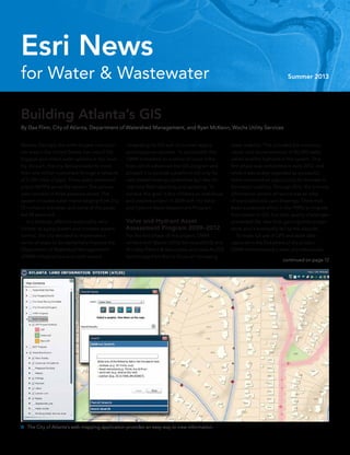
  • 1. continued on page 12 for Water & Wastewater Summer 2013 Esri News Atlanta, Georgia, the ninth-largest metropoli- tan area in the United States, has one of the biggest and oldest water systems in the coun- try. As such, the city delivers water to more than one million customers through a network of 2,700 miles of pipe. Three water treatment plants (WTPs) serve the system. The service area consists of three pressure zones. The system includes water mains ranging from 2 to 72 inches in diameter, and some of the pipes are 90 years old. In a strategic effort to sustainably reha- bilitate its aging system and increase system control, the city decided to implement a series of steps to fundamentally improve the Department of Watershed Management’s (DWM) infrastructure and work toward Building Atlanta’s GIS By Dax Flinn, City of Atlanta, Department of Watershed Management, and Ryan McKeon, Wachs Utility Services integrating its GIS with its current legacy and enterprise systems. To accomplish this, DWM embarked on a series of major initia- tives, which advanced the GIS program and allowed it to provide a platform not only for web-based viewing capabilities but also for real-time field reporting and updating. To achieve this goal, it first initiated an ambitious and creative project in 2009 with the Valve and Hydrant Asset Assessment Program. Valve and Hydrant Asset Assessment Program 2009–2012 For the first phase of this project, DWM worked with Wachs Utility Services (WUS) and Brindley Pieters & Associates and used ArcGIS technology from Esri to focus on increasing asset usability. This included the inventory, repair, and documentation of 80,000 water valves and fire hydrants in the system. This first phase was completed in early 2012, and while it was widely regarded as successful, there remained an opportunity to increase in- formation usability. Through 2012, the primary information system of record was an atlas of nonscaled plat card drawings. There had been a previous effort in the 1990s to migrate from paper to GIS, but data quality challenges prevented the idea from gaining wide accept- ance, and it eventually fell by the wayside. To make full use of GPS and asset data captured in the first phase of the project, DWM commissioned a team of professionals  The City of Atlanta’s web mapping application provides an easy way to view information.
  • 2. 2 Esri News for Water & Wastewater  Summer 2013 Summer 2013 Esri News for Water & Wastewater is a publication of the Water/Wastewater Group of Esri. To contact the Esri Desktop Order Center, call 1-800-447-9778 within the United States or 909-793-2853, ext. 1-1235, outside the United States. Visit the Esri website at esri.com. View Esri News for Water & Wastewater online at esri.com/waterwrites or scan the code below with your smartphone. Advertise with Us E-mail ads@esri.com. Submit Content To submit articles for publication in Esri News for Water & Wastewater, contact Lori Armstrong, industry solutions manager, at larmstrong@esri.com or Jessica Wyland, editor, at jwyland@esri.com. Manage Your Subscription To update your mailing address or subscribe or unsubscribe to Esri publications, visit esri.com/publications. International customers should contact an Esri distributor to manage their subscriptions. For a directory of distributors, visit esri.com/distributors. Circulation Services For back issues, missed issues, and other circulation services, e-mail requests@esri.com; call 909-793-2853, extension 2778; or fax 909-798-0560. Contents Cover 1 Building Atlanta’s GIS Case Study 3 Serving Customers with a Mobile Work Order System 5 “If You Build It, They Will Become Aware” 8 Mobile App Opens Customer Interaction Partner Corner 9 Spatial Wave Software Benefits ArcGIS Users 10 Securing Water Quality through Mobile Mapping 12 Basic GIS Proves Innovative in a Developing Country 13 Esri Online 13 On the Road 14 What Does the Esri UC Offer You? The information contained in this work is the exclusive property of Esri or its licensors. This work is protected under United States copyright law and other international copyright treaties and conventions. No part of this work may be reproduced or transmitted in any form or by any means, electronic or mechanical, including photocopying and recording, or by any information storage or retrieval system, except as expressly permitted in writing by Esri. All requests should be sent to Attention: Contracts and Legal Services Manager, Esri, 380 New York Street, Redlands, CA 92373-8100 USA. The information contained in this work is subject to change without notice. The Geographic Advantage, Esri, the Esri globe logo, 3D Analyst, ArcAtlas, ArcCatalog, ArcData, ArcDoc, ArcEditor, ArcExplorer, ArcGIS, the ArcGIS logo, ArcGlobe, ArcIMS, ARC/INFO, ArcInfo, ArcLogistics, ArcMap, ArcNetwork, ArcNews, ArcObjects, ArcPad, ArcPress, ArcReader, ArcSDE, ArcSurvey, ArcToolbox, ArcTools, ArcUser, ArcView, ArcVoyager, ArcWatch, ArcWeb, ArcWorld, ArcXML, Business Analyst Online, BusinessMAP, CommunityInfo, EDN, Geography Network, GIS Day, MapData, MapObjects, Maplex, MapStudio, ModelBuilder, MOLE, NetEngine, RouteMAP, SDE, Sourcebook•America, StreetMap, Tapestry, @esri.com, esri.com, arcgis.com, geographynetwork.com, gis.com, and gisday.com are trademarks, service marks, or registered marks of Esri in the United States, the European Community, or certain other jurisdictions. Other companies and products or services mentioned herein may be trademarks, service marks, or registered marks of their respective mark owners. Copyright © 2013 Esri. All rights reserved. Printed in the United States of America.
  • 3. 3Summer 2013  esri.com/waterwrites Elsinore Valley Municipal Water District (EVMWD) has provided water service in California’s Riverside County for 55 years. EVMWD covers a 96-square-mile area along the Interstate 15 corridor and has approximately 40,000 water, wastewater, and agricultural services satisfying a population of approximately 133,000. It is anticipated that water demand will double within 10 years. EVMWD employs 160 dedicated staff. In 2009, EVMWD went live with a customer information system (CIS). This robust system was designed to handle a number of customer service workflows including the issuing and processing of service orders. Over the next year, the district identified areas in which it would like to improve the CIS workflow pro- cess. For example, a service order (SO) would be completed in the field and subsequently processed back in the office. At the time, the procedure was to generate an SO in the CIS, then print it out and hand it off to the field personnel who would cover a designated area of the district. The field per- sonnel would then fill out information on the paper forms, and at the end of the day that information would have to be reentered into the CIS manually by a dedicated staff member. This created a situation of duplicate data entry. Another challenge faced was when new service orders and updates came in through- out the day, there was no easy mechanism to get that information out to the field other than a phone call or summoning the field staff back into the office. With an area of 96 square miles, this became a logistics nightmare. “We are looking to save time by not having to complete the service orders in the office and instead completing them in the field,” said Tammy Ramirez, meter services super- intendent. “We need a mechanism to move information out to the field and then back into the CIS in a more streamlined manner.” The goal now was to look for a commercial off-the-shelf (COTS) mobile workflow solution that would integrate with the CIS and solve the aforementioned issues. The district also Serving Customers with a Mobile Work Order System Elsinore Valley Municipal Water District Goes Paperless By James A. Ollerton, Water Employee Services Authority  Field Mapplet Mobile Highlighted Service Order continued on page 4 Case Study had interest in discovering a solution that could satisfy additional criteria. The district had a well-developed Esri-based GIS and immediately realized the benefits of a solution that would take advantage of the GIS data. A computerized maintenance management system (CMMS) was in place that was in need of a GIS-based mobile component. The district wanted a single mobile solution that could address other field crew activity that did not relate necessarily to the CIS or CMMS. As can be seen from the criteria pattern so far, it can be said that the district was looking to support one mobile solution, thus reducing the internal administrative challenges of sup- porting multiple platforms. Finally, cost was a key factor from a licensing standpoint, in addition to the services involved, to do what was needed. EVMWD briefly considered the idea of having the CIS accessible out in the field through remote connection but quickly rejected this idea due to a similar pilot effort for remote connection of the CMMS. It was decided from this pilot project that critical workflow applications out in the field should be able to perform in disconnected mode. The district also was considering a mobile so- lution sold as a separate module from the CIS. It would satisfy the immediate need of the CIS workflow issues but fell short of all the other additional criteria. The district also looked at other mobile platforms but was either not impressed by the workflow architecture or felt that the level of expertise was only in niche workflows handled through the system and would require major costs from an additional consultant to make an integration successful. Ultimately, EVMWD selected the Field Mapplet solution from Spatial Wave. EVMWD’s long history of involvement with Esri’s Water/Wastewater group helped the district learn of Spatial Wave. After Spatial Wave had shown to the district the solution and approach that it would take
  • 4. 4 Esri News for Water & Wastewater  Summer 2013 for integration, it was decided that this was the right way to go. Another key factor that played a role was the fact that the Field Mapplet solution was GIS based and would take advantage of the district’s mature geodatabase. Another feature was the ability to take advantage of ArcGIS web services and the ability to execute ArcGIS geoprocessing tasks. “The GIS-based solution has helped in areas where I didn’t even realize there could be improvement; for example, the console  Field Mapplet Mobile Highlighted Service Order  Service Order Summary Form in Field Mapplet Serving Customers with a Mobile Work Order System  continued from page 3 is a good managing tool where I can gauge work visually with the GIS map and reallocate work as needed,” said Carol Mallard, billing specialist. Now, district field services representatives have full access to the robust GIS database and construction drawings. Ultimately, the GIS solution enabled the field crews from both CIS and operations departments to obtain and perform their work in the field. Some of the key capabilities of integration with CIS included the following: •• The exchange of information between CIS Infinity and Field Mapplet was in real time. Customer service requests will show up on the mobile units after synchronizing the unit. •• The process of creating service orders in CIS Infinity passed the information to Field Mapplet in order that a service request can be created in Field Mapplet. •• Service orders could now be delegated easily by area of responsibility. •• Mobile printer configuration allows printing of labels and door hangers on the fly, out in the field. •• Route optimizing saves time and resources. •• The process of completing service requests in Field Mapplet passed information to CIS in order that the service order can be com- pleted and the meter info can be updated in CIS. In addition, EVMWD is taking full advantage of all the other extensions of Field Mapplet including valve exercising, advanced fire flow testing, underground service alerts, redlines, and soon-to-be-implemented sewer line cleaning. Also, EVMWD anticipates soon having the Field Mapplet mobile GIS solution completely integrated with the CMMS. With all this spatial metadata now being collected and more to come, the district has wasted no time in developing reports and GIS viewing services that display the data in a manner that only engages the staff better and helps them understand more about what is going on at the district. GIS has enabled the district to implement a unified mobile solution to process customer service workflows, CMMS work orders, and other field workflows, such as underground service alert ticket processing, which are not managed by these systems. In addition, Field Mapplet has replaced the district’s hard-copy facility atlas data with a robust electronic mobile atlas while allowing for redlining of the data. Combining Esri technology and the Spatial Wave solution has resulted in optimiz- ing district resource utilization while continu- ously improving the quality of the GIS.
  • 5. 5Summer 2013  esri.com/waterwrites Case Study continued on page 6 It started as a free, public sewer infrastructure map for Toms River, New Jersey. Len Bundra, IT and GIS director for Toms River Municipal Utilities Authority (TRMUA), built it in 2004. Then, he kept adding layers. He added aerial imagery, parcel data, and information from agencies such as the New Jersey Department of Transportation, the US Department of Agriculture, and the US Census Bureau. Bundra had one belief in mind: “If you build it, they will become aware.” He was right. When Hurricane Sandy hit the East Coast of the United States in October 2012, the map was suddenly the go-to information source for emergency responders, utilities, public works, private surveyors, and local assessors. Bundra quickly updated the map—known officially as the Toms River Municipal Utilities Authority GIS Map. He added poststorm satellite imagery from the National Oceanic and Atmospheric Administration (NOAA) along with current floodplain delineations and Sandy high water mark data from the Federal Emergency Management Agency (FEMA). “If You Build It, They Will Become Aware” Integrated Web Map Aids Sandy Relief Efforts By Jessica Wyland, Esri  NOAA imagery for the Barrier Island areas of Toms River. Above shows before Sandy. Below shows after Sandy. Anyone who needed to quickly get an accurate picture of the Sandy situation could click the TRMUA GIS Map. Bundra built it, and people did come. Police and fire fighters came to determine where to deploy resources. Electric, gas, and water companies came to decide where to start restoring services. Homeowners, evacuated and eager to survey the damage to their property, came to look at before-and-after aerial photos. And, as Bundra predicted, people most definitely did become aware. “The map served as a valuable resource for the police department after Sandy,” said Mike Burke, IT and 911 coordinator for the Toms
  • 6. 6 Esri News for Water & Wastewater  Summer 2013 River Police Department. “We relied on that visual representation—the before-and-after layers—to set up security perimeters and determine where to place cement barriers.” Since the TRMUA GIS Map was built on the Esri ArcGIS platform and hosted by Amazon Web Services, it provides virtually unlimited power for analysis, collaboration, and spatial data processing. For example, following the storm, many outside contractors arrived on the shores of New Jersey to restore the region’s infrastructure. One group in particular was engineers who needed to figure out the best plan for repaving roads. The TRMUA GIS Map helped them find their way around unfamiliar areas. They were able to use the map to locate important elements such as parcels, street addresses, hydrants, and underground utilities. In the weeks and months following Sandy, the map continued to help. Utilities used it to review parcel polygons on the barrier islands to identify houses and neighborhoods that “If You Build It, They Will Become Aware” continued from page 5 Before Bundra created the map, Otten said TRMUA engineers had to sift through a room of drawers with thousands of engineering drawings for information or request data from other departments or agencies. Often, they would have to send out crews for field visits. Now everything they need is on the computer screen with an aerial basemap.  Otten says he can now view maps of all 430 miles of pipe, 9,600 manholes, and 18 pump stations, along with all attributes. At a glance, he can see whether a pipe or manhole has been inspected or rehabilitated and then simply click to view an inspection report or video. He can access various aerial maps, including post-Hurricane Sandy and aerial basemaps from as far back as 1930. He can tell when a service lateral has been cut were destroyed so those ratepayers would not be charged for the year 2013. The map’s links to FEMA flood advisory maps is helping af- fected townships adopt a new flood insurance risk map. Bundra also recently added a layer to show houses that are slated for demoli- tion and/or labeled uninhabitable to advise citizens and utility companies on where to focus rebuilding infrastructure. For Bundra’s own company, the TRMUA GIS Map continued to serve as a hub. “Simply stated, the Toms River MUA GIS Map is a comprehensive, one-stop shopping data- base of all useful pieces of information for everyone within TRMUA, as well as contrac- tors, plumbers, consultants, and more,” said Nicholas Otten, authority engineer for Toms River Municipal Utilities Authority. “All various pieces of data are centralized and accessible by every TRMUA department within the office or in the field.”
  • 7. 7Summer 2013  esri.com/waterwrites and capped and see the triangulated location sketch of the curb cleanout. The map shows all billing information, in- cluding the recorded number of fixtures within a building. It also shows pump station data and the number of connections flowing to the station, hundreds of pages of data on emer- gency generators, wiring diagrams, pertinent engineering drawings, and pump curves. “With a few clicks, I am also able to generate specific reports,” Otten said. “With GIS, I can determine the approximate, average flow within any given pipe segment. I can list pipes and manholes by name. I can find the names and mailing addresses of property owners within 200 feet of one of our construction projects.” History of GIS at TRMUA TRMUA began its GIS work in 2005 in an effort to assemble 40 years of paper plans and files into a centralized mapping interface. The system was built entirely by in-house staff, without the use of any outside consultants, and was completed within two years. All 9,600 of TRMUA’s sewer manholes had exact coordinates verified in the field using submeter GPS units. More than 600,000 line and manhole attributes were entered into an Esri geodatabase from more than 3,000 engineering plans. In addition, an entire GIS parcel basemap was created from scratch to include additional elements not typically found on the tax maps. For example, 3,000 individual condo units and all major apartment buildings were added to the basemap, which was then aligned to New Jersey State US Geological Survey (USGS) orthophotography. The system is now available for all TRMUA office staff across an internal network and to all field staff via ruggedized laptop units.  “The GIS has increased operational efficiencies across all departments by allowing instanta- neous access to data that previously had to be searched for amongst reams of paper files and plans,” Bundra said. “The GIS also allows our field crews access to all the information they need to quickly assess and properly ad- dress emergency situations.”  There are 2,558 points hyperlinked to post- Sandy aerial oblique photographs from Civil Air Patrol added to the TRMUA GIS Map. Case Study
  • 8. 8 Esri News for Water & Wastewater  Summer 2013 The Washington Suburban Sanitary Commission (WSSC), headquar- tered in Laurel, Maryland, recently used Esri technology to develop a mobile application where customers can pay bills, report out­ages, and check the status of a service request. The mobile solution increased customer satisfaction by providing functionality 24/7 via iPhone, Android, or BlackBerry smartphones. Customers can use WSSC Mobile to pay all or a portion of their bill, view bill and payment history, purchase watershed use permits, and see a historical graph of actual household water consumption. Customers can also report problems immediately to WSSC staff and check for updates on service alerts in their area. Established in 1918, WSSC is among the largest water and waste- water utilities in the nation, with a network of nearly 5,600 miles of freshwater pipeline and more than 5,400 miles of sewer pipeline. The company serves 1.8 million residents through approximately 460,000 customer accounts. WSSC drinking water has always met or exceeded federal standards. WSSC operates and maintains three reservoirs, two water filtration plants, and six wastewater treatment plants. “We needed a more efficient way to interact with customers without tying them to desktop computers,” said Mujib Lodhi, chief information officer for WSSC. “We also saw an opportunity to improve service and repair operations using data gathered by customers’ mobile devices.” The ability to report an outage—complete with location informa- tion and images—is particularly useful to WSSC. It potentially adds 1.8 million pairs of eyes, those of the customer base, to help monitor nearly 11,000 miles of water and wastewater system infrastructure. Within the customer contact center, Lodhi said they anticipate reductions in call volume and call-handling times, as well as the near elimina­tion of the rou- tine customer requests that can be more easily handled through the mobile application. Quicker incident reporting will lead to faster repairs, dol- lars saved, and better service for the community when it comes to water incidents and emergencies. To build the mobile app, WSSC used its existing industry- standard web and Esri ArcGIS ar- chitecture, the IBM WebSphere suite for all Java 2 Enterprise Edition (J2EE) applications, and Oracle for the relational data- base man­agement system. Mobile App Opens Customer Interaction Washington Suburban Sanitary Commission  Using the WSSC mobile application, customers can pay bills, report outages, and check the status of a service request.
  • 9. 9Summer 2013  esri.com/waterwrites Partner Corner Spatial Wave Software delivers high-quality, innovative, GIS-based software products for those seeking to maximize their investment in ArcGIS from Esri. Spatial Wave Software was formerly the products division of DCSE, a California-based engineering and GIS consult- ing firm, and has been an Esri partner since 1996. Spatial Wave products are designed based on over 25 years of GIS experience delivering solutions to water and wastewater utilities. The Spatial Wave product family includes Mapplet, a robust workflow and operations dashboard; Field Mapplet, a mobile workflow solution; and Mapplet Library, a GIS-based map and document management system. Each of these solutions has the ability to work independently of each other. Field Mapplet is specially designed to manage any workflow that spans office and field, including underground service alerts, work orders, customer service requests, peri- odic monitoring, and inspections. MP/USA is a configuration of Field Mapplet supporting a utility’s one-call process. Field Mapplet easily integrates with an organization’s tabular, document, and Esri data environments. Mapplet enables users across the enter- prise to gain access to data and documents from a spatial perspective. Mapplet is integrated with ArcGIS API for Silverlight from Esri. It allows you to gain access to data from all aspects of your organization, including cus- tomer service, field operations, engineering, and finance, and any other enterprise data to which you wish to connect. Mapplet Library is a web-based application for distributed sharing of thematic ArcGIS maps. Mapplet Library has been deployed at numerous water districts to make it easier to find and view large libraries of maps already Spatial Wave Software Benefits ArcGIS Users created by multiple departments. It reduces the tech­nical proficiency needed and in- creases the audience within your organization who can benefit from GIS assets. In fact, in the early days of Mapplet Library, thousands of Esri International User Conference (Esri UC) attendees were using the application at the Map Gallery to submit and retrieve entries for the Map Gallery competition. Spatial Wave is a single vendor with exten- sive experience providing proven, integrated solutions and services for water and wastewater utilities. Spatial Wave is known for providing a cost-effective solution suite that is easy to use, proven, efficient, and cost-effective to maintain. Spatial Wave understands the needs of water and wastewater agencies, anticipates the future needs of a district, provides additional solutions, and scales with each client’s needs. Visit www.spatialwave.com.  GIS Platform and Powerful Organization Viewer  GIS for Spatially Enabled Workflows  Mobile Solutions for Utility Field Crews
  • 10. 10 Esri News for Water & Wastewater  Summer 2013 Residents of Collingwood in southern Ontario, Canada, can rest assured that the water distribution system they depend on is in good hands thanks to a unique mobile application. Developed using ArcGIS, the app supports effective fire hydrant flushing throughout the town—a central component to delivering clean water. Fire hydrant flushing is one of the most important practices that can be performed on a water distribution system and provides an opportunity to check for leaks, proper valve operation, corrosion and rust, water pressure, and chlorine levels. If ignored, corrosion and rust can cause serious public safety concerns, not to mention threats to water quality. In the town of Collingwood, fire hydrant maintenance is carried out by Collingwood Public Utilities/COLLUS Power, a municipally owned utility that provides both water and electricity services. With a commitment to continuous improvement through innovative business processes and technology, COLLUS signed an enterprise license agreement (ELA) with Esri Canada Limited so that it could cost- effectively deploy multiple licenses of ArcGIS and integrate the software into the weekly and annual flushing program. “Our field operations have rapidly evolved,” said Jody Wilson, GIS technician, COLLUS. “We’ve expanded from a few licenses to running ArcGIS in 12 of our trucks. As a result, we’re operating more productively, and our ability to capture accurate data has grown by leaps and bounds.” Each week, operators flush out what’s known as “dead end” hydrants—hydrants located at the end of a street that receive water from a single direction. These hydrants must be checked on a regular basis to ensure “We’re working more efficiently and are much better equipped to demonstrate compliance. Our reports are no longer based on assumptions. Through GIS, we’re able to ensure complete accuracy when audited.” —Jody Wilson, COLLUS Securing Water Quality through Mobile Mapping By Barry Kelly, Esri Canada Limited that they are fully functional and that chlorine levels are in line with government standards. Flushing the hydrants involves opening one of the three ports of the hydrant and allowing the water to flow wide open. Crews check for ease of opening and closing, ensure that water flow stops when the hydrant is shut down, and check to see if remaining water drains down below ground level into the sur- rounding soil. If a hydrant does not perform all these functions with ease, the hydrant is flagged for repair. To record results, operators use GPS- enabled ruggedized mobile units that provide access to basemaps; orthoimagery; and layers of data such as parcels, property boundaries, parks, and streets. When conducting a flush, a new task is opened in ArcGIS, and the operator fills out a series of attributes that are pulled from the utility’s main database. Attributes include the operator’s name, the date of the flush, current chlorine levels, the amount of water flushed, and the hydrant’s pounds per square inch (PSI). A user-friendly touch screen makes it quick and easy to record the results of the inspec- tion and move on to the next hydrant. Once the operator returns to the office and is within wireless range, all the new data is instantly synced back to the main database. Then models created using ArcGIS enable data to be automatically calculated. For exam- ple, the amount of waste resulting from a flush can be instantly generated and included in reports required for annual audits. “We’re working more efficiently and are much better equipped to demonstrate compliance,” said Wilson. “Our reports are no longer based on assumptions. Through GIS, we’re able to report on exactly how many hydrants were flushed, for what length of time, as well as the volume of water flushed to ensure complete accuracy when audited.” In addition to weekly dead-end flushes, COLLUS is responsible for conducting a bian- nual inspection of the town’s 1,200 hydrants. GIS is used to keep an up-to-date inventory of the hydrants and analyze each asset’s history. To carry out the biannual flushes, four trucks are dispatched to different areas of the town. Through shared access to the data, all four
  • 11. 11Summer 2013  esri.com/waterwrites operators can ensure that no hydrants are missed during the inspection. When an asset is identified as in need of repair, operators mark this on the attribute form, and a call for service is placed immediately. Previously, operators would record data by creating hand-drawn checklists in Excel spreadsheets. The sheets would then be stapled together, placed in a binder, and used during the annual audit. Using this system, the utility was not able to automatically call up data, perform calculations, or analyze the asset’s history. “We can now pull up a five- to six-year his- tory of a hydrant and proactively troubleshoot any potential issues pertaining to that asset,” said Wilson. “For example, if we receive a complaint from a resident regarding a water issue, we’re able to instantly view nearby hydrants, check the condition, and see the date of the last flush to get to the root of the problem.” In the near future, COLLUS will look at ex- tending GIS capabilities to Apple and Android devices so that operators in the field will be able to capture data using smartphones or tablets. Visit esricanada.com.  The Identify tool in ArcGIS is used on a recently added hydrant inspection. The Identify Results window shows inspections dating back to 2007, which can be individually selected and viewed by operators in the field. Partner Corner
  • 12. 12 Esri News for Water & Wastewater  Summer 2013 Basic GIS Proves Innovative in a Developing Country By Rochelle Holm, Washington State University  Shallow well water quality results from Mzuzu, Malawi, are plotted using ArcGIS. On a recent rainy day, researchers were huddled in a small laboratory in the Central African country of Malawi, conducting water quality analysis with onlookers eager for GIS maps depicting the results. Few individuals in Malawi are trained in GIS skills, and within the university setting, GIS theory, rather than practical application, is the standard. In January 2012, a laboratory for water quality testing was established at the Mzuzu University Centre for Water and Sanitation, Malawi, through a partnership with Washington State University in the United States. In Malawi, university attendance is only 0.6 percent of the population, limiting trained personnel in the water and sanita- tion sector and those with GIS skills. In many areas of Malawi, the risk to human health from microbial drinking water contamination is not known. This lack of data poses a unique chal- lenge for governmental and nongovernmental agencies working to protect human health and the environment. Basic skills in Esri’s ArcGIS technology were recently used in combination with a water quality investigation conducted in Mzuzu in northern Malawi. Although the area has municipal piped water service, shallow wells are still used for drinking by some households. ArcGIS provided a powerful and innovative tool to visually depict the results of this investigation as part of a risk communication program. Results were reported back to individual households at the conclusion of the project as part of a targeted risk com- munication program in an effort to encourage behaviors that protect both human health and the environment in this developing country. Building Atlanta’s GIS  continued from cover to construct a water utility GIS. This phase of the project focused on the consolidation of data spread across 7,000 plat card drawings, hundreds of thousands of inspection records, and 80,000 GPS data points into a spatially accurate, content rich, and widely available GIS. In addition, DWM employed GIS to support water network hydraulic modeling initiatives, operations and maintenance activities, and capital improvement planning. The Valve and Hydrant Asset Assessment Program named two key objectives: restore Atlanta’s water distribution system of approxi- mately 48,000 valves and 24,000 fire hydrants to maximum operability, and develop a GIS database with necessary water system transmission and distribution asset records and GPS locations to meet water utility asset management and maintenance requirements.  Shallow well data collection is performed. Phase I began in 2009. With a three-month time limit, the team began preparing a base of operations at the Peyton Road DWM Pipe Yard. This included permitting, preparation of the yard, procuring equipment, building ser- vice trucks, setting up the computer network, and all internal processes. Phase II began during the final days of setup at Peyton Road. Field Services included the core scope of the primary objective to assess 48,000 valves and 24,000 hydrants and com- plete in-scope repairs on valves. During these assessments and repairs, more than 100 pieces of data were collected on each asset, including the GPS location. This data was compiled and analyzed scrupulously to meet the needs of the utility to complete a functioning GIS. To reach assessment and repair goals, the city first worked on pilot areas, then focused on places where the hydrant flow was not per the minimum standard. By January 2012, the information services team was delivering data on a weekly basis. The first delivery of 12,511 assets and each subsequent delivery only contained assets that had gone through the entire assess- ment cycle. This means that each valve and hydrant in the delivery was exercised, made accessible, repaired if necessary, and had its GPS points logged. Furthermore, each piece of data has gone through QA/QC and GIS processes to ensure accurate information and location for the asset. Phase III began in April 2012 and included utilizing the information for the valves and hydrants collected under the Valve and Hydrant Asset Assessment Program; the group would create the geometric network
  • 13. Mark Your Calendar Esri International User Conference July 8–12, 2013 San Diego, CA USA www.esri.com/events/user-conference National Rural Water Association H2O XPO October 1–3, 2013 Louisville, KY USA www.h2o-xpo.org Water Environment Federation Technical Exhibition and Conference (WEFTEC) October 5–9, 2013 Chicago, IL USA www.weftec.org Pollutec Horizons December 3–6, 2013 Paris, France www.pollutec.com/GB.htm On the Road 13Summer 2013  esri.com/waterwrites Follow the Esri Water Community on Twitter Keep up with the latest GIS news, especially as it relates to the water industry, by following Esri on Twitter: @esriteamwater Watch Recorded Webinars Visit esri.com/water and look under Announcements for new webinars including Hydraulic Modeling and GIS and Services and Solutions for the Water Utility Industry. Access for Water Utilities This website is for the ArcGIS water, wastewater, and storm water utility community. It provides useful templates and best practice in- formation enabling you to implement ArcGIS to manage your water utility information, perform your daily operations, and support your long-term planning. Visit resources.arcgis.com/content/water-utilities. Esri Onlinedepicting the pipes that connect the valves and hydrants together in a functioning hydraulic network. This data, in conjunction with the DWM plat cards showing pipe connections and relative pipe locations, was used to build a geometric network for modeling the flow of water in the water transmission and distribution system. Phase III was success- fully completed in December 2012. By the end of the project, the team had surpassed its goal by assess- ing its targeted valves and hydrants on time, updated and vastly im- proved the water distribution system GIS, and come in under budget. Additional Benefits Hospital Corridor The city of Atlanta was in the process of replacing a bridge at Peachtree-Dunwoody Road. Along that bridge is a main that feeds seven hospitals. In the event that the main was disturbed, the team wanted to be proactive and make sure there was a secondary feed. It redirected a crew to locate certain valves that, if necessary, could create a new zone to feed the hospitals. A crew spent 1.5 days locating and making accessible seven valves along the hospital corridor in Sandy Springs. Now, should there be a disruption, the city can immediately execute the rezoning plans. North Treatment Plant The North Treatment Plant located in Johns Creek has a 48-foot transmission main running 12 miles that feeds the city. A valve replacement stopped treatment plant pumping for 24 hours. This provided a perfect time to exercise valves along the main. To take advantage of the downtime, a crew was sent out to locate and identify all the city’s valves along the main. Making a trip prior to shutdown allowed all the valves to be exercised in a short period of time. Searching through woods and along the 400 Toll Road, 12 of 15 valves were located and made accessible. The remaining three could not be found because of poor loca- tion data. The team exhausted all standard locating techniques, including the use of ground penetrating radar, in an extensive search to find the last three. Instead, GPS was used to pinpoint the area where the team believed them to be. More Advancements With the support of the executive offices within DWM, the GIS Division has implemented a migration of the GIS datasets to the ArcGIS Local Government Information Model; introduced ArcGIS for Windows Mobile; purchased new data servers and updated major application components; built a new web mapping application called the Atlanta Land Information System (ATLIS); integrated GIS and electronic documents and files with the DWM Electronic Content Management System (ECMS); and is looking to ArcGIS Online and its local government integration capabilities by moving toward smartphones and tablets for increased integra- tion of field reporting, viewing, and communication. It has been an ambitious road, and the benefits can be seen by the wealth of information now available to the department.
  • 14. 14 Esri News for Water & Wastewater  Summer 2013 This year, the Esri International User Conference (Esri UC) promises inspiration, collaboration, and practical application for water, wastewater, and stormwater profession- als. This conference will provide an opportu- nity to be surrounded by thousands of fellow GIS professionals who have found innovative solutions to common challenges. Plan to attend the following moderated paper presentations and technical workshops designed specifically for water, wastewater, and stormwater professionals: •• ArcGIS Online for Water, Wastewater, and Stormwater •• Enterprise GIS •• Getting the Most Out of Your Assets •• GIS Tools for Stormwater Billing •• GIS Implementation What Does the Esri UC Offer You? •• GIS for Stormwater Management •• Web Technologies for Water •• Water Modeling and GIS •• Innovations in Water GIS •• GIS and Asset Management •• Using GIS for Field Operations •• GIS for Wastewater •• SCADA and GIS Check out the Team Water/Wastewater/ Stormwater Meeting scheduled for Saturday, July 6. And, be sure to attend the Special Interest Group Meeting at noon on Wednesday, July 10. Plus, the annual Pool Party will be held at the Hilton San Diego Bayfront at 7:00 p.m., Wednesday, July 10. During the Esri UC, you’ll be able to visit the Solutions Island in the GIS Solutions EXPO to speak with Esri experts about ArcGIS for water utilities. Participate in the Water Utility Data Health Checks each day of the Esri UC. Schedule a 45-minute review and analysis of your data from Esri’s water utility experts. In addition to examining data accuracy, they will use ArcGIS Data Reviewer for Desktop to run diagnostics and evaluate overall data quality. If you maintain parcel data, they will also be able to assess whether or not it is ready to be loaded into the parcel fabric. To schedule an appointment, e-mail datareviewer @esri.com with your name, organization, con- tact information, and preferred date and time. For more Esri UC info, visit esri.com/uc. Esri International User Conference You are GIS. You gain knowledge, share expertise, and help us understand our world. There’s a place where GIS goes beyond coordinates, breaks free of categories, and reaches past analysis. A place where products are launched, ideas are shared, and inspiration is set loose. Join us at the Esri UC. Register today at esri.com/ucwater. United we map! Esri International User Conference July 8–12, 2013 | San Diego Convention Center Copyright © 2013 Esri. All rights reserved.
  • 16. Presorted Standard US Postage Paid Esri 380 New York Street Redlands, California 92373-8100  usa 135661  xxxxx6/13sp 30-day free trial: esri.com/agol Creating your own map from maps published by other users is just one of many ways to take advantage of the rich collection of data and resources ArcGIS SM Online makes available to you. Welcome to the new frontier in geographic information systems. ArcGIS Online Copyright © 2012 Esri. All rights reserved. 30-day free trial: esri.com/agol Creating your own map from maps published by other users is just one of many ways to take advantage of the rich collection of data and resources ArcGIS SM Online makes available to you. Welcome to the new frontier in geographic information systems. ArcGIS Online Maps made better. (Some assembly required.) Copyright © 2012 Esri. All rights reserved.