SlideShare uma empresa Scribd logo
1 de 2
Baixar para ler offline
Esri Roads and Highways
®

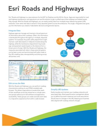
Esri Roads and Highways is a new extension for ArcGIS for Desktop and ArcGIS for Server. Agencies responsible for road
and highway maintenance, and operations can use this solution to get a unified view of the roadways and related assets
they manage. With Esri Roads and Highways, you can easily overlay data from multiple linear referencing system (LRS)
networks—even when that data is stored in many separate systems across the enterprise. This single, integrated view gives
you the information you need to make better decisions and generate reports.
®

®

Integrate Data
Highway agencies manage and maintain a broad spectrum
of information about their roadways. Often, this information
is distributed throughout the agency in multiple, disparate
systems. For example, the public safety department might
maintain crash data based on mileposts located along the
highway, while the maintenance department may locate
sign and pavement assets based on the distance from a
known point of origin. With Esri Roads and Highways, the
measures associated with data in these external systems
can be kept current and synchronized with edits made to
the LRS, enabling data interoperability and sharing across
all business units.

Safety

Repairs

Pavement

Roads &
Highways

Other Assets

Planning

Edit across the Web
With Esri Roads and Highways, you can perform roadway
characteristics editing on any HTML5-enabled web
browser. This allows organizations to extend the reach
of their workflows across the enterprise to include users
and groups without prior GIS software and application
accessibility. These groups can create and edit event data
in a mapcentric experience from within a web browser.

Simplify LRS Updates
Easily visualize and maintain your roadway networks and
associated data. Rule-based location management allows
you to define how event measures and route associations
should react to changes in the LRS, keeping your business
data aligned with roadway network changes.
Better Workflow Management Tools
Coordinate and track work throughout your organization
using standardized and streamlined workflows. Workflow
management tools provide visibility into day-to-day job
progress, allowing you to track the status of jobs. A history
of actions is automatically recorded for each job, providing
a detailed account of how the job was completed.

Analyze and Report Data When You Need It
Esri Roads and Highways spatially enables business data
from sources other than the geographic information
system (GIS) and integrates it through the LRS. Esri Roads
and Highways, in concert with the ArcGIS platform, can be
used to generate a variety of reports as well as produce
data products and maps that support safety analysis, traffic
congestion studies, and infrastructure maintenance.
These reports and data products can provide government
and public entities with transparency in many facets of
highway-based data such as assets, incidents, and
roadway characteristics.

Comprehensive Quality Control Tools
Esri Roads and Highways includes a complete QA/QC
system with tools for automated and visual review processes
to assess, document, correct, and verify the overall quality
of your spatial data. The tools can be scheduled to run
automatically and are configurable so you can implement
business rules specific to your
organization’s needs.

Copyright © 2014 Esri. All rights reserved. Esri, the Esri globe logo, ArcGIS, @esri.com, and esri.com are trademarks, service marks, or
registered marks of Esri in the United States, the European Community, or certain other jurisdictions. Other companies and products or
services mentioned herein may be trademarks, service marks, or registered marks of their respective mark owners.

139933

ESRI3C2/14ca

Request a free trial at
esri.com/roadsandhighways,
or e-mail roadsandhighways
@esri.com for more information.

Mais conteúdo relacionado

Semelhante a Esri Roads and Highways

ArcGIS for Desktop
ArcGIS for DesktopArcGIS for Desktop
ArcGIS for DesktopEsri
 
GIS as strategic management tool
GIS as strategic management toolGIS as strategic management tool
GIS as strategic management toolJonas Baile
 
Implementing ArcGIS for Water Utilities
Implementing ArcGIS for Water UtilitiesImplementing ArcGIS for Water Utilities
Implementing ArcGIS for Water UtilitiesEsri
 
Using OGC Standards To Link BI and Spatial
Using OGC Standards To Link BI and SpatialUsing OGC Standards To Link BI and Spatial
Using OGC Standards To Link BI and SpatialMISNet - Integeo SE Asia
 
Summer 2013
Summer 2013Summer 2013
Summer 2013Esri
 
ArcGIS for Transportation Analytics
ArcGIS for Transportation AnalyticsArcGIS for Transportation Analytics
ArcGIS for Transportation AnalyticsEsri
 
ArcGIS Online
ArcGIS OnlineArcGIS Online
ArcGIS OnlineEsri
 
ArcGIS por
ArcGIS porArcGIS por
ArcGIS porWizoAli
 
Esri News for Federal Government Winter 2012/2013 issue
Esri News for Federal Government Winter 2012/2013 issueEsri News for Federal Government Winter 2012/2013 issue
Esri News for Federal Government Winter 2012/2013 issueEsri
 
GIS for Facilities Overview
GIS for Facilities OverviewGIS for Facilities Overview
GIS for Facilities OverviewEsri
 
Esri News for Petroleum Winter 2013/2014 newsletter
Esri News for Petroleum Winter 2013/2014 newsletterEsri News for Petroleum Winter 2013/2014 newsletter
Esri News for Petroleum Winter 2013/2014 newsletterEsri
 
Esri Location Analytics: Four Implementation Models
Esri Location Analytics: Four Implementation ModelsEsri Location Analytics: Four Implementation Models
Esri Location Analytics: Four Implementation ModelsEsri
 
FlightlineGeo_ESRI_Newsletter_winter2014
FlightlineGeo_ESRI_Newsletter_winter2014FlightlineGeo_ESRI_Newsletter_winter2014
FlightlineGeo_ESRI_Newsletter_winter2014Devon Humphrey
 
Analyze performance and operations of truck fleets in real time
Analyze performance and operations of truck fleets in real timeAnalyze performance and operations of truck fleets in real time
Analyze performance and operations of truck fleets in real timeAltair
 
Future of GIS, Moving to the Enterprise Platform
Future of GIS, Moving to the Enterprise PlatformFuture of GIS, Moving to the Enterprise Platform
Future of GIS, Moving to the Enterprise PlatformSSP Innovations
 
Field Mobile Workforce Management solution for utility industry
Field Mobile Workforce Management solution for utility industryField Mobile Workforce Management solution for utility industry
Field Mobile Workforce Management solution for utility industryCrave InfoTech
 
Mapping for Advanced Business Analytics - ArcGIS Business Analyst
Mapping for Advanced Business Analytics - ArcGIS Business AnalystMapping for Advanced Business Analytics - ArcGIS Business Analyst
Mapping for Advanced Business Analytics - ArcGIS Business AnalystEsri Ireland
 
ArcGIS for Local Government
ArcGIS for Local GovernmentArcGIS for Local Government
ArcGIS for Local GovernmentEsri
 

Semelhante a Esri Roads and Highways (20)

ArcGIS for Desktop
ArcGIS for DesktopArcGIS for Desktop
ArcGIS for Desktop
 
GIS as strategic management tool
GIS as strategic management toolGIS as strategic management tool
GIS as strategic management tool
 
Implementing ArcGIS for Water Utilities
Implementing ArcGIS for Water UtilitiesImplementing ArcGIS for Water Utilities
Implementing ArcGIS for Water Utilities
 
Using OGC Standards To Link BI and Spatial
Using OGC Standards To Link BI and SpatialUsing OGC Standards To Link BI and Spatial
Using OGC Standards To Link BI and Spatial
 
Summer 2013
Summer 2013Summer 2013
Summer 2013
 
ArcGIS for Transportation Analytics
ArcGIS for Transportation AnalyticsArcGIS for Transportation Analytics
ArcGIS for Transportation Analytics
 
ArcGIS Online
ArcGIS OnlineArcGIS Online
ArcGIS Online
 
ArcGIS por
ArcGIS porArcGIS por
ArcGIS por
 
Esri News for Federal Government Winter 2012/2013 issue
Esri News for Federal Government Winter 2012/2013 issueEsri News for Federal Government Winter 2012/2013 issue
Esri News for Federal Government Winter 2012/2013 issue
 
Gis in transportation
Gis in transportationGis in transportation
Gis in transportation
 
GIS for Facilities Overview
GIS for Facilities OverviewGIS for Facilities Overview
GIS for Facilities Overview
 
Esri News for Petroleum Winter 2013/2014 newsletter
Esri News for Petroleum Winter 2013/2014 newsletterEsri News for Petroleum Winter 2013/2014 newsletter
Esri News for Petroleum Winter 2013/2014 newsletter
 
Esri Location Analytics: Four Implementation Models
Esri Location Analytics: Four Implementation ModelsEsri Location Analytics: Four Implementation Models
Esri Location Analytics: Four Implementation Models
 
FlightlineGeo_ESRI_Newsletter_winter2014
FlightlineGeo_ESRI_Newsletter_winter2014FlightlineGeo_ESRI_Newsletter_winter2014
FlightlineGeo_ESRI_Newsletter_winter2014
 
Analyze performance and operations of truck fleets in real time
Analyze performance and operations of truck fleets in real timeAnalyze performance and operations of truck fleets in real time
Analyze performance and operations of truck fleets in real time
 
Future of GIS, Moving to the Enterprise Platform
Future of GIS, Moving to the Enterprise PlatformFuture of GIS, Moving to the Enterprise Platform
Future of GIS, Moving to the Enterprise Platform
 
Field Mobile Workforce Management solution for utility industry
Field Mobile Workforce Management solution for utility industryField Mobile Workforce Management solution for utility industry
Field Mobile Workforce Management solution for utility industry
 
Mapping for Advanced Business Analytics - ArcGIS Business Analyst
Mapping for Advanced Business Analytics - ArcGIS Business AnalystMapping for Advanced Business Analytics - ArcGIS Business Analyst
Mapping for Advanced Business Analytics - ArcGIS Business Analyst
 
David Miller Retired
David Miller RetiredDavid Miller Retired
David Miller Retired
 
ArcGIS for Local Government
ArcGIS for Local GovernmentArcGIS for Local Government
ArcGIS for Local Government
 

Mais de Esri

INIA- CISA: Análisis de las amenazas en la fauna silvestre
INIA- CISA: Análisis de las amenazas en la fauna silvestreINIA- CISA: Análisis de las amenazas en la fauna silvestre
INIA- CISA: Análisis de las amenazas en la fauna silvestreEsri
 
Aena Aeropuerto Adolfo Suárez-Barajas crea potentes aplicaciones para sus cli...
Aena Aeropuerto Adolfo Suárez-Barajas crea potentes aplicaciones para sus cli...Aena Aeropuerto Adolfo Suárez-Barajas crea potentes aplicaciones para sus cli...
Aena Aeropuerto Adolfo Suárez-Barajas crea potentes aplicaciones para sus cli...Esri
 
Portal for ArcGIS
Portal for ArcGISPortal for ArcGIS
Portal for ArcGISEsri
 
GIS-Based Web Services Provide Rapid Analysis and Dissemination of Maritime Data
GIS-Based Web Services Provide Rapid Analysis and Dissemination of Maritime DataGIS-Based Web Services Provide Rapid Analysis and Dissemination of Maritime Data
GIS-Based Web Services Provide Rapid Analysis and Dissemination of Maritime DataEsri
 
An Effective Tool for Drinking Water Protection
An Effective Tool for Drinking Water ProtectionAn Effective Tool for Drinking Water Protection
An Effective Tool for Drinking Water ProtectionEsri
 
GeoCollector for ArcPad
GeoCollector for ArcPadGeoCollector for ArcPad
GeoCollector for ArcPadEsri
 
GeoCollector for ArcGIS for Windows Mobile
GeoCollector for ArcGIS for Windows MobileGeoCollector for ArcGIS for Windows Mobile
GeoCollector for ArcGIS for Windows MobileEsri
 
Data Appliance for ArcGIS
Data Appliance for ArcGISData Appliance for ArcGIS
Data Appliance for ArcGISEsri
 
Esri and BlackBridge
Esri and BlackBridgeEsri and BlackBridge
Esri and BlackBridgeEsri
 
GeoPlanner for ArcGIS
GeoPlanner for ArcGISGeoPlanner for ArcGIS
GeoPlanner for ArcGISEsri
 
Esri and AccuWeather
Esri and AccuWeatherEsri and AccuWeather
Esri and AccuWeatherEsri
 
Esri and Airbus Defense & Space
Esri and Airbus Defense & SpaceEsri and Airbus Defense & Space
Esri and Airbus Defense & SpaceEsri
 
Esri US Data Fact Sheet
Esri US Data Fact SheetEsri US Data Fact Sheet
Esri US Data Fact SheetEsri
 
ArcGIS for Server on Microsoft Azure Jumpstart
ArcGIS for Server on Microsoft Azure JumpstartArcGIS for Server on Microsoft Azure Jumpstart
ArcGIS for Server on Microsoft Azure JumpstartEsri
 
ArcGIS for the Military--Maritime Operations
ArcGIS for the Military--Maritime OperationsArcGIS for the Military--Maritime Operations
ArcGIS for the Military--Maritime OperationsEsri
 
Esri Geoportal Server
Esri Geoportal ServerEsri Geoportal Server
Esri Geoportal ServerEsri
 
ArcGIS GeoEvent Extension for Server
ArcGIS GeoEvent Extension for ServerArcGIS GeoEvent Extension for Server
ArcGIS GeoEvent Extension for ServerEsri
 
The NATO Core Geographic Services System
The NATO Core Geographic Services SystemThe NATO Core Geographic Services System
The NATO Core Geographic Services SystemEsri
 
ArcGIS for Desktop Tips and Shortcuts
ArcGIS for Desktop Tips and ShortcutsArcGIS for Desktop Tips and Shortcuts
ArcGIS for Desktop Tips and ShortcutsEsri
 
ArcGIS: A Platform for Intelligent 3D Imagery
ArcGIS: A Platform for Intelligent 3D ImageryArcGIS: A Platform for Intelligent 3D Imagery
ArcGIS: A Platform for Intelligent 3D ImageryEsri
 

Mais de Esri (20)

INIA- CISA: Análisis de las amenazas en la fauna silvestre
INIA- CISA: Análisis de las amenazas en la fauna silvestreINIA- CISA: Análisis de las amenazas en la fauna silvestre
INIA- CISA: Análisis de las amenazas en la fauna silvestre
 
Aena Aeropuerto Adolfo Suárez-Barajas crea potentes aplicaciones para sus cli...
Aena Aeropuerto Adolfo Suárez-Barajas crea potentes aplicaciones para sus cli...Aena Aeropuerto Adolfo Suárez-Barajas crea potentes aplicaciones para sus cli...
Aena Aeropuerto Adolfo Suárez-Barajas crea potentes aplicaciones para sus cli...
 
Portal for ArcGIS
Portal for ArcGISPortal for ArcGIS
Portal for ArcGIS
 
GIS-Based Web Services Provide Rapid Analysis and Dissemination of Maritime Data
GIS-Based Web Services Provide Rapid Analysis and Dissemination of Maritime DataGIS-Based Web Services Provide Rapid Analysis and Dissemination of Maritime Data
GIS-Based Web Services Provide Rapid Analysis and Dissemination of Maritime Data
 
An Effective Tool for Drinking Water Protection
An Effective Tool for Drinking Water ProtectionAn Effective Tool for Drinking Water Protection
An Effective Tool for Drinking Water Protection
 
GeoCollector for ArcPad
GeoCollector for ArcPadGeoCollector for ArcPad
GeoCollector for ArcPad
 
GeoCollector for ArcGIS for Windows Mobile
GeoCollector for ArcGIS for Windows MobileGeoCollector for ArcGIS for Windows Mobile
GeoCollector for ArcGIS for Windows Mobile
 
Data Appliance for ArcGIS
Data Appliance for ArcGISData Appliance for ArcGIS
Data Appliance for ArcGIS
 
Esri and BlackBridge
Esri and BlackBridgeEsri and BlackBridge
Esri and BlackBridge
 
GeoPlanner for ArcGIS
GeoPlanner for ArcGISGeoPlanner for ArcGIS
GeoPlanner for ArcGIS
 
Esri and AccuWeather
Esri and AccuWeatherEsri and AccuWeather
Esri and AccuWeather
 
Esri and Airbus Defense & Space
Esri and Airbus Defense & SpaceEsri and Airbus Defense & Space
Esri and Airbus Defense & Space
 
Esri US Data Fact Sheet
Esri US Data Fact SheetEsri US Data Fact Sheet
Esri US Data Fact Sheet
 
ArcGIS for Server on Microsoft Azure Jumpstart
ArcGIS for Server on Microsoft Azure JumpstartArcGIS for Server on Microsoft Azure Jumpstart
ArcGIS for Server on Microsoft Azure Jumpstart
 
ArcGIS for the Military--Maritime Operations
ArcGIS for the Military--Maritime OperationsArcGIS for the Military--Maritime Operations
ArcGIS for the Military--Maritime Operations
 
Esri Geoportal Server
Esri Geoportal ServerEsri Geoportal Server
Esri Geoportal Server
 
ArcGIS GeoEvent Extension for Server
ArcGIS GeoEvent Extension for ServerArcGIS GeoEvent Extension for Server
ArcGIS GeoEvent Extension for Server
 
The NATO Core Geographic Services System
The NATO Core Geographic Services SystemThe NATO Core Geographic Services System
The NATO Core Geographic Services System
 
ArcGIS for Desktop Tips and Shortcuts
ArcGIS for Desktop Tips and ShortcutsArcGIS for Desktop Tips and Shortcuts
ArcGIS for Desktop Tips and Shortcuts
 
ArcGIS: A Platform for Intelligent 3D Imagery
ArcGIS: A Platform for Intelligent 3D ImageryArcGIS: A Platform for Intelligent 3D Imagery
ArcGIS: A Platform for Intelligent 3D Imagery
 

Último

Potential of AI (Generative AI) in Business: Learnings and Insights
Potential of AI (Generative AI) in Business: Learnings and InsightsPotential of AI (Generative AI) in Business: Learnings and Insights
Potential of AI (Generative AI) in Business: Learnings and InsightsRavi Sanghani
 
So einfach geht modernes Roaming fuer Notes und Nomad.pdf
So einfach geht modernes Roaming fuer Notes und Nomad.pdfSo einfach geht modernes Roaming fuer Notes und Nomad.pdf
So einfach geht modernes Roaming fuer Notes und Nomad.pdfpanagenda
 
Unleashing Real-time Insights with ClickHouse_ Navigating the Landscape in 20...
Unleashing Real-time Insights with ClickHouse_ Navigating the Landscape in 20...Unleashing Real-time Insights with ClickHouse_ Navigating the Landscape in 20...
Unleashing Real-time Insights with ClickHouse_ Navigating the Landscape in 20...Alkin Tezuysal
 
How AI, OpenAI, and ChatGPT impact business and software.
How AI, OpenAI, and ChatGPT impact business and software.How AI, OpenAI, and ChatGPT impact business and software.
How AI, OpenAI, and ChatGPT impact business and software.Curtis Poe
 
Connecting the Dots for Information Discovery.pdf
Connecting the Dots for Information Discovery.pdfConnecting the Dots for Information Discovery.pdf
Connecting the Dots for Information Discovery.pdfNeo4j
 
Digital Identity is Under Attack: FIDO Paris Seminar.pptx
Digital Identity is Under Attack: FIDO Paris Seminar.pptxDigital Identity is Under Attack: FIDO Paris Seminar.pptx
Digital Identity is Under Attack: FIDO Paris Seminar.pptxLoriGlavin3
 
Passkey Providers and Enabling Portability: FIDO Paris Seminar.pptx
Passkey Providers and Enabling Portability: FIDO Paris Seminar.pptxPasskey Providers and Enabling Portability: FIDO Paris Seminar.pptx
Passkey Providers and Enabling Portability: FIDO Paris Seminar.pptxLoriGlavin3
 
Assure Ecommerce and Retail Operations Uptime with ThousandEyes
Assure Ecommerce and Retail Operations Uptime with ThousandEyesAssure Ecommerce and Retail Operations Uptime with ThousandEyes
Assure Ecommerce and Retail Operations Uptime with ThousandEyesThousandEyes
 
The Future Roadmap for the Composable Data Stack - Wes McKinney - Data Counci...
The Future Roadmap for the Composable Data Stack - Wes McKinney - Data Counci...The Future Roadmap for the Composable Data Stack - Wes McKinney - Data Counci...
The Future Roadmap for the Composable Data Stack - Wes McKinney - Data Counci...Wes McKinney
 
Arizona Broadband Policy Past, Present, and Future Presentation 3/25/24
Arizona Broadband Policy Past, Present, and Future Presentation 3/25/24Arizona Broadband Policy Past, Present, and Future Presentation 3/25/24
Arizona Broadband Policy Past, Present, and Future Presentation 3/25/24Mark Goldstein
 
A Journey Into the Emotions of Software Developers
A Journey Into the Emotions of Software DevelopersA Journey Into the Emotions of Software Developers
A Journey Into the Emotions of Software DevelopersNicole Novielli
 
Enhancing User Experience - Exploring the Latest Features of Tallyman Axis Lo...
Enhancing User Experience - Exploring the Latest Features of Tallyman Axis Lo...Enhancing User Experience - Exploring the Latest Features of Tallyman Axis Lo...
Enhancing User Experience - Exploring the Latest Features of Tallyman Axis Lo...Scott Andery
 
TrustArc Webinar - How to Build Consumer Trust Through Data Privacy
TrustArc Webinar - How to Build Consumer Trust Through Data PrivacyTrustArc Webinar - How to Build Consumer Trust Through Data Privacy
TrustArc Webinar - How to Build Consumer Trust Through Data PrivacyTrustArc
 
Sample pptx for embedding into website for demo
Sample pptx for embedding into website for demoSample pptx for embedding into website for demo
Sample pptx for embedding into website for demoHarshalMandlekar2
 
Long journey of Ruby standard library at RubyConf AU 2024
Long journey of Ruby standard library at RubyConf AU 2024Long journey of Ruby standard library at RubyConf AU 2024
Long journey of Ruby standard library at RubyConf AU 2024Hiroshi SHIBATA
 
Transcript: New from BookNet Canada for 2024: Loan Stars - Tech Forum 2024
Transcript: New from BookNet Canada for 2024: Loan Stars - Tech Forum 2024Transcript: New from BookNet Canada for 2024: Loan Stars - Tech Forum 2024
Transcript: New from BookNet Canada for 2024: Loan Stars - Tech Forum 2024BookNet Canada
 
A Deep Dive on Passkeys: FIDO Paris Seminar.pptx
A Deep Dive on Passkeys: FIDO Paris Seminar.pptxA Deep Dive on Passkeys: FIDO Paris Seminar.pptx
A Deep Dive on Passkeys: FIDO Paris Seminar.pptxLoriGlavin3
 
TeamStation AI System Report LATAM IT Salaries 2024
TeamStation AI System Report LATAM IT Salaries 2024TeamStation AI System Report LATAM IT Salaries 2024
TeamStation AI System Report LATAM IT Salaries 2024Lonnie McRorey
 
Genislab builds better products and faster go-to-market with Lean project man...
Genislab builds better products and faster go-to-market with Lean project man...Genislab builds better products and faster go-to-market with Lean project man...
Genislab builds better products and faster go-to-market with Lean project man...Farhan Tariq
 
Why device, WIFI, and ISP insights are crucial to supporting remote Microsoft...
Why device, WIFI, and ISP insights are crucial to supporting remote Microsoft...Why device, WIFI, and ISP insights are crucial to supporting remote Microsoft...
Why device, WIFI, and ISP insights are crucial to supporting remote Microsoft...panagenda
 

Último (20)

Potential of AI (Generative AI) in Business: Learnings and Insights
Potential of AI (Generative AI) in Business: Learnings and InsightsPotential of AI (Generative AI) in Business: Learnings and Insights
Potential of AI (Generative AI) in Business: Learnings and Insights
 
So einfach geht modernes Roaming fuer Notes und Nomad.pdf
So einfach geht modernes Roaming fuer Notes und Nomad.pdfSo einfach geht modernes Roaming fuer Notes und Nomad.pdf
So einfach geht modernes Roaming fuer Notes und Nomad.pdf
 
Unleashing Real-time Insights with ClickHouse_ Navigating the Landscape in 20...
Unleashing Real-time Insights with ClickHouse_ Navigating the Landscape in 20...Unleashing Real-time Insights with ClickHouse_ Navigating the Landscape in 20...
Unleashing Real-time Insights with ClickHouse_ Navigating the Landscape in 20...
 
How AI, OpenAI, and ChatGPT impact business and software.
How AI, OpenAI, and ChatGPT impact business and software.How AI, OpenAI, and ChatGPT impact business and software.
How AI, OpenAI, and ChatGPT impact business and software.
 
Connecting the Dots for Information Discovery.pdf
Connecting the Dots for Information Discovery.pdfConnecting the Dots for Information Discovery.pdf
Connecting the Dots for Information Discovery.pdf
 
Digital Identity is Under Attack: FIDO Paris Seminar.pptx
Digital Identity is Under Attack: FIDO Paris Seminar.pptxDigital Identity is Under Attack: FIDO Paris Seminar.pptx
Digital Identity is Under Attack: FIDO Paris Seminar.pptx
 
Passkey Providers and Enabling Portability: FIDO Paris Seminar.pptx
Passkey Providers and Enabling Portability: FIDO Paris Seminar.pptxPasskey Providers and Enabling Portability: FIDO Paris Seminar.pptx
Passkey Providers and Enabling Portability: FIDO Paris Seminar.pptx
 
Assure Ecommerce and Retail Operations Uptime with ThousandEyes
Assure Ecommerce and Retail Operations Uptime with ThousandEyesAssure Ecommerce and Retail Operations Uptime with ThousandEyes
Assure Ecommerce and Retail Operations Uptime with ThousandEyes
 
The Future Roadmap for the Composable Data Stack - Wes McKinney - Data Counci...
The Future Roadmap for the Composable Data Stack - Wes McKinney - Data Counci...The Future Roadmap for the Composable Data Stack - Wes McKinney - Data Counci...
The Future Roadmap for the Composable Data Stack - Wes McKinney - Data Counci...
 
Arizona Broadband Policy Past, Present, and Future Presentation 3/25/24
Arizona Broadband Policy Past, Present, and Future Presentation 3/25/24Arizona Broadband Policy Past, Present, and Future Presentation 3/25/24
Arizona Broadband Policy Past, Present, and Future Presentation 3/25/24
 
A Journey Into the Emotions of Software Developers
A Journey Into the Emotions of Software DevelopersA Journey Into the Emotions of Software Developers
A Journey Into the Emotions of Software Developers
 
Enhancing User Experience - Exploring the Latest Features of Tallyman Axis Lo...
Enhancing User Experience - Exploring the Latest Features of Tallyman Axis Lo...Enhancing User Experience - Exploring the Latest Features of Tallyman Axis Lo...
Enhancing User Experience - Exploring the Latest Features of Tallyman Axis Lo...
 
TrustArc Webinar - How to Build Consumer Trust Through Data Privacy
TrustArc Webinar - How to Build Consumer Trust Through Data PrivacyTrustArc Webinar - How to Build Consumer Trust Through Data Privacy
TrustArc Webinar - How to Build Consumer Trust Through Data Privacy
 
Sample pptx for embedding into website for demo
Sample pptx for embedding into website for demoSample pptx for embedding into website for demo
Sample pptx for embedding into website for demo
 
Long journey of Ruby standard library at RubyConf AU 2024
Long journey of Ruby standard library at RubyConf AU 2024Long journey of Ruby standard library at RubyConf AU 2024
Long journey of Ruby standard library at RubyConf AU 2024
 
Transcript: New from BookNet Canada for 2024: Loan Stars - Tech Forum 2024
Transcript: New from BookNet Canada for 2024: Loan Stars - Tech Forum 2024Transcript: New from BookNet Canada for 2024: Loan Stars - Tech Forum 2024
Transcript: New from BookNet Canada for 2024: Loan Stars - Tech Forum 2024
 
A Deep Dive on Passkeys: FIDO Paris Seminar.pptx
A Deep Dive on Passkeys: FIDO Paris Seminar.pptxA Deep Dive on Passkeys: FIDO Paris Seminar.pptx
A Deep Dive on Passkeys: FIDO Paris Seminar.pptx
 
TeamStation AI System Report LATAM IT Salaries 2024
TeamStation AI System Report LATAM IT Salaries 2024TeamStation AI System Report LATAM IT Salaries 2024
TeamStation AI System Report LATAM IT Salaries 2024
 
Genislab builds better products and faster go-to-market with Lean project man...
Genislab builds better products and faster go-to-market with Lean project man...Genislab builds better products and faster go-to-market with Lean project man...
Genislab builds better products and faster go-to-market with Lean project man...
 
Why device, WIFI, and ISP insights are crucial to supporting remote Microsoft...
Why device, WIFI, and ISP insights are crucial to supporting remote Microsoft...Why device, WIFI, and ISP insights are crucial to supporting remote Microsoft...
Why device, WIFI, and ISP insights are crucial to supporting remote Microsoft...
 

Esri Roads and Highways

  • 1. Esri Roads and Highways ® Esri Roads and Highways is a new extension for ArcGIS for Desktop and ArcGIS for Server. Agencies responsible for road and highway maintenance, and operations can use this solution to get a unified view of the roadways and related assets they manage. With Esri Roads and Highways, you can easily overlay data from multiple linear referencing system (LRS) networks—even when that data is stored in many separate systems across the enterprise. This single, integrated view gives you the information you need to make better decisions and generate reports. ® ® Integrate Data Highway agencies manage and maintain a broad spectrum of information about their roadways. Often, this information is distributed throughout the agency in multiple, disparate systems. For example, the public safety department might maintain crash data based on mileposts located along the highway, while the maintenance department may locate sign and pavement assets based on the distance from a known point of origin. With Esri Roads and Highways, the measures associated with data in these external systems can be kept current and synchronized with edits made to the LRS, enabling data interoperability and sharing across all business units. Safety Repairs Pavement Roads & Highways Other Assets Planning Edit across the Web With Esri Roads and Highways, you can perform roadway characteristics editing on any HTML5-enabled web browser. This allows organizations to extend the reach of their workflows across the enterprise to include users and groups without prior GIS software and application accessibility. These groups can create and edit event data in a mapcentric experience from within a web browser. Simplify LRS Updates Easily visualize and maintain your roadway networks and associated data. Rule-based location management allows you to define how event measures and route associations should react to changes in the LRS, keeping your business data aligned with roadway network changes.
  • 2. Better Workflow Management Tools Coordinate and track work throughout your organization using standardized and streamlined workflows. Workflow management tools provide visibility into day-to-day job progress, allowing you to track the status of jobs. A history of actions is automatically recorded for each job, providing a detailed account of how the job was completed. Analyze and Report Data When You Need It Esri Roads and Highways spatially enables business data from sources other than the geographic information system (GIS) and integrates it through the LRS. Esri Roads and Highways, in concert with the ArcGIS platform, can be used to generate a variety of reports as well as produce data products and maps that support safety analysis, traffic congestion studies, and infrastructure maintenance. These reports and data products can provide government and public entities with transparency in many facets of highway-based data such as assets, incidents, and roadway characteristics. Comprehensive Quality Control Tools Esri Roads and Highways includes a complete QA/QC system with tools for automated and visual review processes to assess, document, correct, and verify the overall quality of your spatial data. The tools can be scheduled to run automatically and are configurable so you can implement business rules specific to your organization’s needs. Copyright © 2014 Esri. All rights reserved. Esri, the Esri globe logo, ArcGIS, @esri.com, and esri.com are trademarks, service marks, or registered marks of Esri in the United States, the European Community, or certain other jurisdictions. Other companies and products or services mentioned herein may be trademarks, service marks, or registered marks of their respective mark owners. 139933 ESRI3C2/14ca Request a free trial at esri.com/roadsandhighways, or e-mail roadsandhighways @esri.com for more information.