08448380779 Call Girls In Diplomatic Enclave Women Seeking Men
Esri Maps for Office
1. Powered by ArcGIS®
Esri Maps for Office
®
®
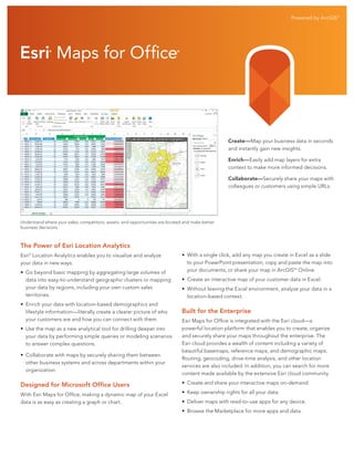
Create—Map your business data in seconds
and instantly gain new insights.
Enrich—Easily add map layers for extra
context to make more informed decisions.
Collaborate—Securely share your maps with
colleagues or customers using simple URLs.
Understand where your sales, competitors, assets, and opportunities are located and make better
business decisions.
The Power of Esri Location Analytics
Esri® Location Analytics enables you to visualize and analyze
your data in new ways.
• Go beyond basic mapping by aggregating large volumes of
data into easy-to-understand geographic clusters or mapping
your data by regions, including your own custom sales
territories.
• Enrich your data with location-based demographics and
lifestyle information—literally create a clearer picture of who
your customers are and how you can connect with them.
• Use the map as a new analytical tool for drilling deeper into
your data by performing simple queries or modeling scenarios
to answer complex questions.
• Collaborate with maps by securely sharing them between
other business systems and across departments within your
organization.
• With a single click, add any map you create in Excel as a slide
to your PowerPoint presentation, copy and paste the map into
your documents, or share your map in ArcGISSM Online.
• Create an interactive map of your customer data in Excel.
• Without leaving the Excel environment, analyze your data in a
location-based context.
Built for the Enterprise
Esri Maps for Office is integrated with the Esri cloud—a
powerful location platform that enables you to create, organize
and securely share your maps throughout the enterprise. The
Esri cloud provides a wealth of content including a variety of
beautiful basemaps, reference maps, and demographic maps.
Routing, geocoding, drive-time analysis, and other location
services are also included. In addition, you can search for more
content made available by the extensive Esri cloud community.
Designed for Microsoft Office Users
• Create and share your interactive maps on-demand.
With Esri Maps for Office, making a dynamic map of your Excel
data is as easy as creating a graph or chart.
• Keep ownership rights for all your data.
• Deliver maps with read-to-use apps for any device.
• Browse the Marketplace for more apps and data.