Enviar pesquisa
Carregar
Alaska Division of Geological and Geophysical Surveys case study
•
1 gostou
•
531 visualizações
Esri
Seguir
case study of Alaska DGGS
Leia menos
Leia mais
Tecnologia
Denunciar
Compartilhar
Denunciar
Compartilhar
1 de 1
Baixar agora
Baixar para ler offline
Recomendados
Case Study: Creating a Geospatial Web Application for National Geographic
Adetola Adewodu
RESUME_Glassman.docx (1)
Michael Glassman
Subsurface 3D GIS 05nov2011
Andrew Zolnai
Overview of geographic information systems (gis)
Evans Library at Florida Institute of Technology
AAPG Geoscience Technology Workshop 2019
Chijioke “CJ” Ejimuda
Managing Data Synchronization Between ArcSDE and POSTGIS using FME
Safe Software
SHAKEEB SHAFIQ Resume
Shakeeb shafiq
Rivero - VIPER
Rivero - VIPER
Carlos Rivero
Ingrid - Power Plants Database
Martin Gascon
Digitization of Cadastral Maps
webaabsys
Office for National Statistics - Smart Data - Esri UK Annual Conference 2017
Esri UK
Final Project Presentation
M Zubair Iqbal
DMIS Work Flow
DMIS Work Flow
Madhur Devkota
Large Scale Geo Processing on Hadoop
Christoph Körner
Computation of spatial data on Hadoop Cluster
Abhishek Sagar
ArcGIS Open Data - Smart Data - Esri UK Annual Conference 2017
Esri UK
Koorosh gobal Resume
Koorosh Gobal
Forestry Commission - Smart Collaboration - Esri UK Annual Conference 2017
Esri UK
An Intro to DI Transform
Drillinginfo
Rule-Driven, Fully-Configurable Asset Tracking with GIS
SSP Innovations
Excel VbA for Technical works (Highway).
Avinash Devela
Leveraging FME to Overcome Challenges in Gas Pipeline Data Enhancement and Do...
Safe Software
Connecting through the OMS
SSP Innovations
CitySprint Fleetmapper use case -Big Data Bootcamp
Eduard Lazar
Resume_update_2015
Resume_update_2015
Travis Thompson
Apresentação IBGE
Apresentação IBGE
Inovação GIS - Tecnologia da Informação
ammos
ammos
Meghan Green
Esri News for Petroleum Winter 2012/2013 newsletter
Esri
GIS for Maritime Users
Esri
Lidar Analysis in ArcGIS® 10.0 for Forestry Applications
Gordon Sumerling
Mais conteúdo relacionado
Mais procurados
Ingrid - Power Plants Database
Martin Gascon
Digitization of Cadastral Maps
webaabsys
Office for National Statistics - Smart Data - Esri UK Annual Conference 2017
Esri UK
Final Project Presentation
M Zubair Iqbal
DMIS Work Flow
DMIS Work Flow
Madhur Devkota
Large Scale Geo Processing on Hadoop
Christoph Körner
Computation of spatial data on Hadoop Cluster
Abhishek Sagar
ArcGIS Open Data - Smart Data - Esri UK Annual Conference 2017
Esri UK
Koorosh gobal Resume
Koorosh Gobal
Forestry Commission - Smart Collaboration - Esri UK Annual Conference 2017
Esri UK
An Intro to DI Transform
Drillinginfo
Rule-Driven, Fully-Configurable Asset Tracking with GIS
SSP Innovations
Excel VbA for Technical works (Highway).
Avinash Devela
Leveraging FME to Overcome Challenges in Gas Pipeline Data Enhancement and Do...
Safe Software
Connecting through the OMS
SSP Innovations
CitySprint Fleetmapper use case -Big Data Bootcamp
Eduard Lazar
Resume_update_2015
Resume_update_2015
Travis Thompson
Apresentação IBGE
Apresentação IBGE
Inovação GIS - Tecnologia da Informação
ammos
ammos
Meghan Green
Mais procurados
(19)
Ingrid - Power Plants Database
Digitization of Cadastral Maps
Office for National Statistics - Smart Data - Esri UK Annual Conference 2017
Final Project Presentation
DMIS Work Flow
DMIS Work Flow
Large Scale Geo Processing on Hadoop
Computation of spatial data on Hadoop Cluster
ArcGIS Open Data - Smart Data - Esri UK Annual Conference 2017
Koorosh gobal Resume
Forestry Commission - Smart Collaboration - Esri UK Annual Conference 2017
An Intro to DI Transform
Rule-Driven, Fully-Configurable Asset Tracking with GIS
Excel VbA for Technical works (Highway).
Leveraging FME to Overcome Challenges in Gas Pipeline Data Enhancement and Do...
Connecting through the OMS
CitySprint Fleetmapper use case -Big Data Bootcamp
Resume_update_2015
Resume_update_2015
Apresentação IBGE
Apresentação IBGE
ammos
ammos
Semelhante a Alaska Division of Geological and Geophysical Surveys case study
Esri News for Petroleum Winter 2012/2013 newsletter
Esri
GIS for Maritime Users
Esri
Lidar Analysis in ArcGIS® 10.0 for Forestry Applications
Gordon Sumerling
Esri News for Federal Government Winter 2012/2013 issue
Esri
Esri News for Water Resources Winter 2012/2013 newsletter
Esri
Extension arc gis
Extension arc gis
Walquer huacani calsin
FlightlineGeo_ESRI_Newsletter_winter2014
Devon Humphrey
Data Appliance for ArcGIS
Esri
How ArcGIS for the Military Supports Maritime Operations
Esri
Free and open source software for remote sensing and GIS
NopphawanTamkuan
Data Sources
Data Sources
Joe Larson
Esri News for Facilities Winter 2012/2013 newsletter
Esri
Paul Zhao-resume
Paul Zhao-resume
Paul Zhao
Arc gis concept
Arc gis concept
Arif Doel
Climate Impacts Water Resources
Esri
IkeGPS Joliet Case Study
GlobalgeoGNSS
Esri News for Oceans Fall 2012 newsletter
Esri
Summer 2013
Summer 2013
Esri
Arcpad
Arcpad
Nur Baqin
Bathymetric Data Management
Esri
Semelhante a Alaska Division of Geological and Geophysical Surveys case study
(20)
Esri News for Petroleum Winter 2012/2013 newsletter
GIS for Maritime Users
Lidar Analysis in ArcGIS® 10.0 for Forestry Applications
Esri News for Federal Government Winter 2012/2013 issue
Esri News for Water Resources Winter 2012/2013 newsletter
Extension arc gis
Extension arc gis
FlightlineGeo_ESRI_Newsletter_winter2014
Data Appliance for ArcGIS
How ArcGIS for the Military Supports Maritime Operations
Free and open source software for remote sensing and GIS
Data Sources
Data Sources
Esri News for Facilities Winter 2012/2013 newsletter
Paul Zhao-resume
Paul Zhao-resume
Arc gis concept
Arc gis concept
Climate Impacts Water Resources
IkeGPS Joliet Case Study
Esri News for Oceans Fall 2012 newsletter
Summer 2013
Summer 2013
Arcpad
Arcpad
Bathymetric Data Management
Mais de Esri
INIA- CISA: Análisis de las amenazas en la fauna silvestre
Esri
Aena Aeropuerto Adolfo Suárez-Barajas crea potentes aplicaciones para sus cli...
Esri
Plataforma Smart City de Móstoles
Esri
ArcGIS Online para Organizaciones
Esri
Molina de Segura se convierte en una smart city
Esri
Portal for ArcGIS
Portal for ArcGIS
Esri
GIS-Based Web Services Provide Rapid Analysis and Dissemination of Maritime Data
Esri
An Effective Tool for Drinking Water Protection
Esri
GeoCollector for ArcPad
Esri
GeoCollector for ArcGIS for Windows Mobile
Esri
Esri and BlackBridge
Esri
GeoPlanner for ArcGIS
Esri
Esri and AccuWeather
Esri
Esri and Airbus Defense & Space
Esri
Esri US Data Fact Sheet
Esri
ArcGIS for Server on Microsoft Azure Jumpstart
Esri
ArcGIS for the Military--Maritime Operations
Esri
Esri Geoportal Server
Esri
ArcGIS GeoEvent Extension for Server
Esri
The NATO Core Geographic Services System
Esri
Mais de Esri
(20)
INIA- CISA: Análisis de las amenazas en la fauna silvestre
Aena Aeropuerto Adolfo Suárez-Barajas crea potentes aplicaciones para sus cli...
Plataforma Smart City de Móstoles
ArcGIS Online para Organizaciones
Molina de Segura se convierte en una smart city
Portal for ArcGIS
Portal for ArcGIS
GIS-Based Web Services Provide Rapid Analysis and Dissemination of Maritime Data
An Effective Tool for Drinking Water Protection
GeoCollector for ArcPad
GeoCollector for ArcGIS for Windows Mobile
Esri and BlackBridge
GeoPlanner for ArcGIS
Esri and AccuWeather
Esri and Airbus Defense & Space
Esri US Data Fact Sheet
ArcGIS for Server on Microsoft Azure Jumpstart
ArcGIS for the Military--Maritime Operations
Esri Geoportal Server
ArcGIS GeoEvent Extension for Server
The NATO Core Geographic Services System
Último
Artificial Intelligence: Facts and Myths
Joaquim Jorge
How to Troubleshoot Apps for the Modern Connected Worker
ThousandEyes
AWS Community Day CPH - Three problems of Terraform
Andrey Devyatkin
GenAI Risks & Security Meetup 01052024.pdf
lior mazor
Boost PC performance: How more available memory can improve productivity
Principled Technologies
MINDCTI Revenue Release Quarter One 2024
MIND CTI
The 7 Things I Know About Cyber Security After 25 Years | April 2024
Rafal Los
Partners Life - Insurer Innovation Award 2024
The Digital Insurer
Mastering MySQL Database Architecture: Deep Dive into MySQL Shell and MySQL R...
Miguel Araújo
Data Cloud, More than a CDP by Matt Robison
Anna Loughnan Colquhoun
TrustArc Webinar - Unlock the Power of AI-Driven Data Discovery
TrustArc
Repurposing LNG terminals for Hydrogen Ammonia: Feasibility and Cost Saving
Edi Saputra
Top 10 Most Downloaded Games on Play Store in 2024
SynarionITSolutions
Top 5 Benefits OF Using Muvi Live Paywall For Live Streams
Roshan Dwivedi
Why Teams call analytics are critical to your entire business
panagenda
Cloud Frontiers: A Deep Dive into Serverless Spatial Data and FME
Safe Software
Bajaj Allianz Life Insurance Company - Insurer Innovation Award 2024
The Digital Insurer
ProductAnonymous-April2024-WinProductDiscovery-MelissaKlemke
Product Anonymous
Real Time Object Detection Using Open CV
Khem
Connector Corner: Accelerate revenue generation using UiPath API-centric busi...
DianaGray10
Último
(20)
Artificial Intelligence: Facts and Myths
How to Troubleshoot Apps for the Modern Connected Worker
AWS Community Day CPH - Three problems of Terraform
GenAI Risks & Security Meetup 01052024.pdf
Boost PC performance: How more available memory can improve productivity
MINDCTI Revenue Release Quarter One 2024
The 7 Things I Know About Cyber Security After 25 Years | April 2024
Partners Life - Insurer Innovation Award 2024
Mastering MySQL Database Architecture: Deep Dive into MySQL Shell and MySQL R...
Data Cloud, More than a CDP by Matt Robison
TrustArc Webinar - Unlock the Power of AI-Driven Data Discovery
Repurposing LNG terminals for Hydrogen Ammonia: Feasibility and Cost Saving
Top 10 Most Downloaded Games on Play Store in 2024
Top 5 Benefits OF Using Muvi Live Paywall For Live Streams
Why Teams call analytics are critical to your entire business
Cloud Frontiers: A Deep Dive into Serverless Spatial Data and FME
Bajaj Allianz Life Insurance Company - Insurer Innovation Award 2024
ProductAnonymous-April2024-WinProductDiscovery-MelissaKlemke
Real Time Object Detection Using Open CV
Connector Corner: Accelerate revenue generation using UiPath API-centric busi...
Alaska Division of Geological and Geophysical Surveys case study
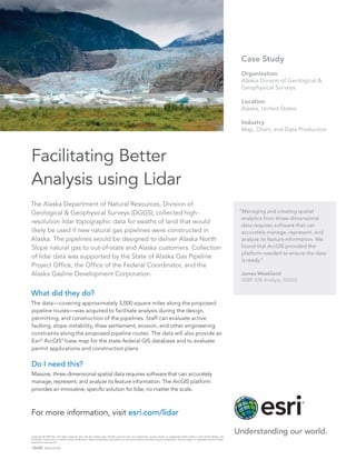
1.
The Alaska Department
of Natural Resources, Division of Geological & Geophysical Surveys (DGGS), collected high- resolution lidar topographic data for swaths of land that would likely be used if new natural gas pipelines were constructed in Alaska. The pipelines would be designed to deliver Alaska North Slope natural gas to out-of-state and Alaska customers. Collection of lidar data was supported by the State of Alaska Gas Pipeline Project Office, the Office of the Federal Coordinator, and the Alaska Gasline Development Corporation. What did they do? The data—covering approximately 3,000 square miles along the proposed pipeline routes—was acquired to facilitate analysis during the design, permitting, and construction of the pipelines. Staff can evaluate active faulting, slope instability, thaw settlement, erosion, and other engineering constraints along the proposed pipeline routes. The data will also provide an Esri® ArcGIS® base map for the state-federal GIS database and to evaluate permit applications and construction plans. Do I need this? Massive, three-dimensional spatial data requires software that can accurately manage, represent, and analyze its feature information. The ArcGIS platform provides an innovative, specific solution for lidar, no matter the scale. “Managing and creating spatial analytics from three-dimensional data requires software that can accurately manage, represent, and analyze its feature information. We found that ArcGIS provided the platform needed to ensure the data is ready.” James Weakland GISP, GIS Analyst, DGGS Facilitating Better Analysis using Lidar Case Study Organization Alaska Divison of Geological & Geophysical Surveys Location Alaska, United States Industry Map, Chart, and Data Production Copyright © 2013 Esri. All rights reserved. Esri, the Esri globe logo, ArcGIS, and esri.com are trademarks, service marks, or registered marks of Esri in the United States, the European Community, or certain other jurisdictions. Other companies and products or services mentioned herein may be trademarks, service marks, or registered marks of their respective mark owners. 136389 ESRI2.5C6/13rk For more information, visit esri.com/lidar
Baixar agora