SlideShare uma empresa Scribd logo
1 de 4
Curriculum Vitae
Name Ayman MahmoudWadiGwanmeh
Place & Date of Birth Irbid – Jordan - 10.05.1963
Nationality Jordanian
Marital Status Married
Gender Male
Address Jordan – Irbid – Zoubya-21663
Mobile +962777770285, +962795961305
Email wadiayman@yahoo.com , giswadi@gmail.com
Seeking for one of the following functions
1 GIS ProjectsManager,GIS Specialist,Building GDB, GIS Applications
2 Cartographer,SeniorSurveyingEngineer,in the field of real estate, property and Urbanism
3 Site Engineer (Supervision,Implementation,Construction,Survey,Topography,Infrastructure)
4
Training,teaching and lecturing in institutes,universitiesand training centers in field of (Survey,GIS,
Photogrammetry, Geodesy, quantities,projectmanagement,GPS).
5 General Director, Administrativedirector
1 High Schoolcertificate, fromIrbid First Secondary School,Irbid – Jordan.
2 B.Sc in Surveying Engineering (Geomatics) /University of Sarajevo (Bosnia) (1982-1989)
3 Chairman of competenceSurvey and GISCertified fromJordan EngineersAssociation
4 Real estate appreciation certificate
1 GIS Manager and ConsultantforNational BroadbandNetworkProject - NBN – (Engicon& MOICT)
2 ToledoCollege,LecturerinSurvey,GIS,GPS,Geodesy, Quantities–Sep2015 – July2016
3
17 yearsof experienceat the RoyalJordanian GeographicCenterin the fields of Geodesy,GIS,RemoteSensing,
Topography,Cartography,AerialPhotography,Photogrammetry,field survey,Mapping and GPS.(1998 -2014)
4
8 years’experiencein the Departmentof Housing and Worksin the field of projectmanagement,Maintenance,
Implementation and supervision,roads,Survey,Infrastructure,topographicand estimatethevaluesof real
estate, propertyand Urbanism(May.1990–Oct.1998)
5
2 yearsof experience withUnited Nationsin GIS UNIT and CartographicDepartment.(dec2000-dec2001) &
(aug2004-aug2005)
6
Projectmanagementexperiencein thefield of Mapping,GIS,GPS, Boundary demarcation,Data management ,
archiving and developmentof dataworkflows.
7 Professionalexperienceusing ESRIsoftware&itsExtensions(ARCGIS,ARCSDE,3DAnalyst,SpatialAnalyst…..).
8 Memberof Committeefor establishing Jordan spatialdata infrastructure JSDIfrom2006.
9 Memberof Arab Union forSurvey and Geomatics
1. Personal Profile / Personal Attributes
3. Education
4. Summary of Work Experience and ProfessionalActivities:
2. Objectives
10
Memberof Committeefor establishing Jordan AVL(VehicleTracking System) forsetting and Establishing of
Execution plan of Vehicle Tracking Systemprojectin Jordan- 2014.
11 GIS Consultant(Management, Applications,Training) forPrivateand Publicsectorsin Jordan.
12
Instructorand Lecturerin GIS,GPS, Survey,ProjectManagement,mapping…In RJGCtraining centre, Prince
Hussein bin Abdullah IIAcademy forCivil Protection and Toledo College – Irbid
13 Memberof Jordan EngineersAssociation fromfeb.1990
Courses taken by ESSRI - Infograph – Jordan:
 Introduction to ArcGISI ESRI Amman 2002
 Using ArcGIS3D &SpatialAnalystESRIAmman 2002
 Working with ArcGISSpatialanalystESRI Amman 2004
 Introduction to ArcSDEESRI Amman 2004
 Introduction to ArcIMSESRIAmman 2004
 Introduction LineTool Sets-PLTS/Infograph
 Developing withArc objects/Infograph
 Working with ArcGISNetworkAnalystESRIAmman 2008
 Survey Analyst/Survey Editor Esri Amman 2008
 Introduction to Military Analyst9.3 ESRIAmman 2009
 QualityAssurance& Qualitycontrol( QA/QC)forGIS Data ESRI Amman 2010
 Portalfor ArcGISUser Training ESRI Amman 2014
 Portalfor ArcGISAdministratorTraining ESRIAmman 2014.
Courses taken by United Nations Institute for Training and Research (UNITAR):
 Commanding UN Peacekeeping Operations
 Mine Action:Humanitarian Impact,TechnicalAspects&GlobalInitiatives
 Peacekeeping & InternationalConflictResolution
 SecurityMeasuresforUN Peacekeepers
 Global Terrorism.
 Advanced Logisticsin Peacekeeping Operations:ContingentOwned Equipment(COE)
 Introduction to theUnited NationsSystem
Courses Taken by UNDP - United Nations Development Programme:
 Tools & techniquesof Crises and Disastersmanagement,UNDPAmman 2008.
 Planning and managing CivilRisks,UNDPAmman 2008.
 The preparation of trainers,UNDPAmman 2009.
Others:
 ProjectManagementProfessionalPMP
 HR – Human resourceManagement
 Engineering ProjectManagementCourse(CPM)
 GeographicInformation Systemand Land Management-TAIWAN 2009
 Sokkia GPS GNSSRTK ModelGRX2, MagnetToolsSoftware& Liscad Surveying Software,Amman 2014.
 ProjectManagementAwarenesssession MICT–Jo- e-Gov Amman 2009
 Geomedia Professional(5.2) GIS software/(GeneralComputer &ElectronicsCo.)
 Mastering MicrosoftVisualBasic6 Fundamentals, MicrosoftAmman 2003.
5. Ancillary Courses & Certificates:
 Mastering MicrosoftVisualBasic6 Development, MicrosoftAmman 2003.
 Mastering EnterpriseDevelopmentUsing MicrosoftVisualBasic6 , MicrosoftAmman 2004.
 ErdasImagineProfessional,VectorModule,VirtualGIS,Subpixel,OrthoBasePro,Stereo Analyst
 Chairman of competence Survey and GIS, Amman Jordan
Associated Consulting Engineers – Jan 2015
 Royal Jordanian Geographic Center, Amman- Jordan, Oct.1998 – Nov. 2014
 Director of Advanced Applications department ,December 2013 - November 2014
 Chief of Land Survey and Geodetic section ,December 2012 – December2013
 Chief Supervision and follow up section- Planning Department, Dec. 2011 - Dec 2012
 Chief Digital Mapping and GIS section ,July 2006 - December 2011
 Chief of Study and Assessment Projects ,Amman- Jordan, 1999 – 2000
 United Nations,
 Chief Geo Cell “GIS UNIT” – Abidjan – Cote devour, August 2004 -August 2005
 Chief Geo Cell “GIS UNIT” – Eritrea & Ethiopia, December 2000- December2001
Attending in the following conferences:
 Remote sensingandGISapplicationsinwater management and irrigation, Turkey – Amasya2003.
 ESRI Conference, SanDiego 2006
 International Civil AviationOrganization,MIDRegionelectronicTerrain andObstacle Amman,2 – 4 July2007
 International Centre For LandPolicyStudies AndTraining,Taiyuan– Taiwan,6 – 18 May2009
Seminaron Geographical InformationSystemandLandManagement.
 ISNET /CSEWorkshopon applications ofSpaceTechnologyfor foodsecurity,9 – 14 July2012 Dakar Senegal
 Modern Trends in trafficsafety,Jordan trafficInstitute– November 2011 Amman– Jordan.
 The 7th Conference ofArab Experts on Geographical Names ,November11 – 13 , 2014 AmmanJordan .
Coordinating, Managing and Advisory Board in the following conferences:
 Pictometry andLiDAR Technologyfor Geospatial Applications,Amman23-10 ,October 2011 Land Mark Hotel
 Enterprise GIS forDefense inthe Contextof the National Security,3d June 2013 – Amman – Jordan
Attending and participating By giving working paper or presentation in the following conferences:
 IIR MiddleEast- PetroGIS(GISin Oil & Gas) Conference,Advanced ApplicationsforGISinOil & Gas
28 March – 1 April 2009, CrownePlaza, ManamaBahrain
Paper title: Geospatial andGISData in Royal JordanianGeographicCentre – Jordan
 Speakingand participatingtheGeospatial IntelligenceMiddleEast2011 on the 15th – 18th May 2011 at the
FairmontBab Al Bahr,AbuDhabi,United ArabEmirates IQPC.
Paper title: DEVELOPING EFFECTIVE GEOSPATIALCAPABILITIES THAT MEET THE NEEDS OF MULTIPLE
STAKEHOLDERS IN JORDAN
Case Study:UsingGIS Technologyto determine the level of safetyor riskto schoolslocatedwithinthe rift valleyin
western part ofJordan.
 The 6th Conference ofArab Experts on Geographical Names andGeodesy,Nov. 29 – 31 , 2013 AmmanJordan
Paper title: the History of GeodeticNetworks in Jordan Observingand CalculatingGroundControl Points
 EuroMed GNSSII /MEDUSAProject (Global NavigationbySatelliteSystemsEGNOS/GALILEO),JordanAmman11th
December,2013
Paper title: the Role of RJGC in Developing Geospatial Capabilities & Building Geospatial Data in Jordan
6. Professional Experience Positionsand Leadership
7. Participationin conferences
 UN-GGIMforthe Arab States MeetingIN Royal JordanianGeographicCentre,Amman,5-6-Feb-2014
Paper title: ImplementationofSpatial Data Infrastructure inJordan JSDI
 Prince Husseinbin AbdullahIIAcademy forCivil Protection 2011/2012
 GeographicInformationSystem(GIS) ,Practical andtheoretical.
 Royal JordanianGeographicCentreCollegeand TrainingCentre forSurvey Sciences,1998 -2014 in the field
of:
 Survey
 Geodesy
 GIS
 GPS
 Real estate –Areas & LandSubdivision
 Terrain Analysis
 Projects Management
 Quantities
 Toledo College, Lecturer in Survey, Geodesy, GIS, RS, Quantities and GPS.
 PublicSafety requirementsfor surveyor and Surveyingdevices / Almiqyas MagazineRJGC -23 issue 2014
 Cadastral networks inthe HashemiteKingdomof Jordan/ Almiqyas MagazineRJGC -22 issue2014
 JordanSpatial Data Infrastructure JSDI / Almiqyas MagazineRJGC -21 issue2013.
 Materialsand SyllabusesinGPS,GIS,Survey, andMappingfor Royal Jordanian GeographicCentretraining
center.
Language Speaking Writing
Arabic Native Native
English v.good v.good
Serbo-Croatians , Bosnian v.good v.good
Upon to Request
8. Instructor and Lecturer in
10. Languages
11. References
9. Author and Writer:

Mais conteúdo relacionado

Destaque

Vat for buy to-let investors mar 15
Vat for buy to-let investors mar 15Vat for buy to-let investors mar 15
Vat for buy to-let investors mar 15taxadvicedirect
 
LoveM_ComprehensiveProject (1)
LoveM_ComprehensiveProject (1)LoveM_ComprehensiveProject (1)
LoveM_ComprehensiveProject (1)Marlaina Love
 
Sailasri_Ramachandran Latest Resume (1)
Sailasri_Ramachandran Latest Resume (1)Sailasri_Ramachandran Latest Resume (1)
Sailasri_Ramachandran Latest Resume (1)sailasri79
 
39Steps_30minute_FINAL
39Steps_30minute_FINAL39Steps_30minute_FINAL
39Steps_30minute_FINALJosh Matthews
 
สารสนเทศเพื่อประกอบการตัดสินใจ
สารสนเทศเพื่อประกอบการตัดสินใจสารสนเทศเพื่อประกอบการตัดสินใจ
สารสนเทศเพื่อประกอบการตัดสินใจminniemild25
 
THE NEXT ELEVEN COUNTRIES EMERGING ECONOMIES
THE NEXT ELEVEN COUNTRIES EMERGING ECONOMIESTHE NEXT ELEVEN COUNTRIES EMERGING ECONOMIES
THE NEXT ELEVEN COUNTRIES EMERGING ECONOMIESMd Faridujaman Nayeem
 
DammProfessional paper04-17-22 (4)
DammProfessional paper04-17-22 (4)DammProfessional paper04-17-22 (4)
DammProfessional paper04-17-22 (4)Sally Damm
 

Destaque (12)

beethove
beethovebeethove
beethove
 
A sixpack in 6 lessons
A sixpack in 6 lessonsA sixpack in 6 lessons
A sixpack in 6 lessons
 
Web apps
Web appsWeb apps
Web apps
 
nhlonipho stanley mthembu
nhlonipho stanley mthembunhlonipho stanley mthembu
nhlonipho stanley mthembu
 
Vat for buy to-let investors mar 15
Vat for buy to-let investors mar 15Vat for buy to-let investors mar 15
Vat for buy to-let investors mar 15
 
LoveM_ComprehensiveProject (1)
LoveM_ComprehensiveProject (1)LoveM_ComprehensiveProject (1)
LoveM_ComprehensiveProject (1)
 
Sailasri_Ramachandran Latest Resume (1)
Sailasri_Ramachandran Latest Resume (1)Sailasri_Ramachandran Latest Resume (1)
Sailasri_Ramachandran Latest Resume (1)
 
Tung74
Tung74Tung74
Tung74
 
39Steps_30minute_FINAL
39Steps_30minute_FINAL39Steps_30minute_FINAL
39Steps_30minute_FINAL
 
สารสนเทศเพื่อประกอบการตัดสินใจ
สารสนเทศเพื่อประกอบการตัดสินใจสารสนเทศเพื่อประกอบการตัดสินใจ
สารสนเทศเพื่อประกอบการตัดสินใจ
 
THE NEXT ELEVEN COUNTRIES EMERGING ECONOMIES
THE NEXT ELEVEN COUNTRIES EMERGING ECONOMIESTHE NEXT ELEVEN COUNTRIES EMERGING ECONOMIES
THE NEXT ELEVEN COUNTRIES EMERGING ECONOMIES
 
DammProfessional paper04-17-22 (4)
DammProfessional paper04-17-22 (4)DammProfessional paper04-17-22 (4)
DammProfessional paper04-17-22 (4)
 

Semelhante a Ayman_CV_eng_sep16

Semelhante a Ayman_CV_eng_sep16 (20)

Emad masadeh resume
Emad masadeh resumeEmad masadeh resume
Emad masadeh resume
 
Bahaa1 CV
Bahaa1 CVBahaa1 CV
Bahaa1 CV
 
my_cv
my_cvmy_cv
my_cv
 
GIS & Database CV
GIS & Database CVGIS & Database CV
GIS & Database CV
 
ezzeldin salah C.V 1
ezzeldin salah C.V 1ezzeldin salah C.V 1
ezzeldin salah C.V 1
 
My CV-civ-Smart
My CV-civ-SmartMy CV-civ-Smart
My CV-civ-Smart
 
M,Mosaad (CV)
M,Mosaad (CV)M,Mosaad (CV)
M,Mosaad (CV)
 
muddasir
muddasir muddasir
muddasir
 
Shaker resume
Shaker resumeShaker resume
Shaker resume
 
CV_Sunil
CV_SunilCV_Sunil
CV_Sunil
 
Nasser Ali -CV 2015
Nasser Ali -CV 2015Nasser Ali -CV 2015
Nasser Ali -CV 2015
 
C. V. GIS Specialist and Analyst
C. V. GIS Specialist and AnalystC. V. GIS Specialist and Analyst
C. V. GIS Specialist and Analyst
 
Why Mapping Drones Are Soaring in Oman.pdf
Why Mapping Drones Are Soaring in Oman.pdfWhy Mapping Drones Are Soaring in Oman.pdf
Why Mapping Drones Are Soaring in Oman.pdf
 
Naim CV on 19.04.2015
Naim CV on 19.04.2015Naim CV on 19.04.2015
Naim CV on 19.04.2015
 
LoayEngCV
LoayEngCVLoayEngCV
LoayEngCV
 
Eman Oriby CV
Eman Oriby CVEman Oriby CV
Eman Oriby CV
 
Abazar Daoud - CV.pdf
Abazar Daoud - CV.pdfAbazar Daoud - CV.pdf
Abazar Daoud - CV.pdf
 
Mehrdad sarhangi 2020 Cv
Mehrdad sarhangi 2020  CvMehrdad sarhangi 2020  Cv
Mehrdad sarhangi 2020 Cv
 
ahmad07 cv2016
ahmad07 cv2016ahmad07 cv2016
ahmad07 cv2016
 
Reda Salib CV
Reda Salib CVReda Salib CV
Reda Salib CV
 

Ayman_CV_eng_sep16

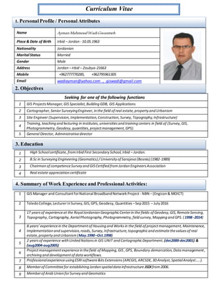
  • 1. Curriculum Vitae Name Ayman MahmoudWadiGwanmeh Place & Date of Birth Irbid – Jordan - 10.05.1963 Nationality Jordanian Marital Status Married Gender Male Address Jordan – Irbid – Zoubya-21663 Mobile +962777770285, +962795961305 Email wadiayman@yahoo.com , giswadi@gmail.com Seeking for one of the following functions 1 GIS ProjectsManager,GIS Specialist,Building GDB, GIS Applications 2 Cartographer,SeniorSurveyingEngineer,in the field of real estate, property and Urbanism 3 Site Engineer (Supervision,Implementation,Construction,Survey,Topography,Infrastructure) 4 Training,teaching and lecturing in institutes,universitiesand training centers in field of (Survey,GIS, Photogrammetry, Geodesy, quantities,projectmanagement,GPS). 5 General Director, Administrativedirector 1 High Schoolcertificate, fromIrbid First Secondary School,Irbid – Jordan. 2 B.Sc in Surveying Engineering (Geomatics) /University of Sarajevo (Bosnia) (1982-1989) 3 Chairman of competenceSurvey and GISCertified fromJordan EngineersAssociation 4 Real estate appreciation certificate 1 GIS Manager and ConsultantforNational BroadbandNetworkProject - NBN – (Engicon& MOICT) 2 ToledoCollege,LecturerinSurvey,GIS,GPS,Geodesy, Quantities–Sep2015 – July2016 3 17 yearsof experienceat the RoyalJordanian GeographicCenterin the fields of Geodesy,GIS,RemoteSensing, Topography,Cartography,AerialPhotography,Photogrammetry,field survey,Mapping and GPS.(1998 -2014) 4 8 years’experiencein the Departmentof Housing and Worksin the field of projectmanagement,Maintenance, Implementation and supervision,roads,Survey,Infrastructure,topographicand estimatethevaluesof real estate, propertyand Urbanism(May.1990–Oct.1998) 5 2 yearsof experience withUnited Nationsin GIS UNIT and CartographicDepartment.(dec2000-dec2001) & (aug2004-aug2005) 6 Projectmanagementexperiencein thefield of Mapping,GIS,GPS, Boundary demarcation,Data management , archiving and developmentof dataworkflows. 7 Professionalexperienceusing ESRIsoftware&itsExtensions(ARCGIS,ARCSDE,3DAnalyst,SpatialAnalyst…..). 8 Memberof Committeefor establishing Jordan spatialdata infrastructure JSDIfrom2006. 9 Memberof Arab Union forSurvey and Geomatics 1. Personal Profile / Personal Attributes 3. Education 4. Summary of Work Experience and ProfessionalActivities: 2. Objectives
  • 2. 10 Memberof Committeefor establishing Jordan AVL(VehicleTracking System) forsetting and Establishing of Execution plan of Vehicle Tracking Systemprojectin Jordan- 2014. 11 GIS Consultant(Management, Applications,Training) forPrivateand Publicsectorsin Jordan. 12 Instructorand Lecturerin GIS,GPS, Survey,ProjectManagement,mapping…In RJGCtraining centre, Prince Hussein bin Abdullah IIAcademy forCivil Protection and Toledo College – Irbid 13 Memberof Jordan EngineersAssociation fromfeb.1990 Courses taken by ESSRI - Infograph – Jordan:  Introduction to ArcGISI ESRI Amman 2002  Using ArcGIS3D &SpatialAnalystESRIAmman 2002  Working with ArcGISSpatialanalystESRI Amman 2004  Introduction to ArcSDEESRI Amman 2004  Introduction to ArcIMSESRIAmman 2004  Introduction LineTool Sets-PLTS/Infograph  Developing withArc objects/Infograph  Working with ArcGISNetworkAnalystESRIAmman 2008  Survey Analyst/Survey Editor Esri Amman 2008  Introduction to Military Analyst9.3 ESRIAmman 2009  QualityAssurance& Qualitycontrol( QA/QC)forGIS Data ESRI Amman 2010  Portalfor ArcGISUser Training ESRI Amman 2014  Portalfor ArcGISAdministratorTraining ESRIAmman 2014. Courses taken by United Nations Institute for Training and Research (UNITAR):  Commanding UN Peacekeeping Operations  Mine Action:Humanitarian Impact,TechnicalAspects&GlobalInitiatives  Peacekeeping & InternationalConflictResolution  SecurityMeasuresforUN Peacekeepers  Global Terrorism.  Advanced Logisticsin Peacekeeping Operations:ContingentOwned Equipment(COE)  Introduction to theUnited NationsSystem Courses Taken by UNDP - United Nations Development Programme:  Tools & techniquesof Crises and Disastersmanagement,UNDPAmman 2008.  Planning and managing CivilRisks,UNDPAmman 2008.  The preparation of trainers,UNDPAmman 2009. Others:  ProjectManagementProfessionalPMP  HR – Human resourceManagement  Engineering ProjectManagementCourse(CPM)  GeographicInformation Systemand Land Management-TAIWAN 2009  Sokkia GPS GNSSRTK ModelGRX2, MagnetToolsSoftware& Liscad Surveying Software,Amman 2014.  ProjectManagementAwarenesssession MICT–Jo- e-Gov Amman 2009  Geomedia Professional(5.2) GIS software/(GeneralComputer &ElectronicsCo.)  Mastering MicrosoftVisualBasic6 Fundamentals, MicrosoftAmman 2003. 5. Ancillary Courses & Certificates:
  • 3.  Mastering MicrosoftVisualBasic6 Development, MicrosoftAmman 2003.  Mastering EnterpriseDevelopmentUsing MicrosoftVisualBasic6 , MicrosoftAmman 2004.  ErdasImagineProfessional,VectorModule,VirtualGIS,Subpixel,OrthoBasePro,Stereo Analyst  Chairman of competence Survey and GIS, Amman Jordan Associated Consulting Engineers – Jan 2015  Royal Jordanian Geographic Center, Amman- Jordan, Oct.1998 – Nov. 2014  Director of Advanced Applications department ,December 2013 - November 2014  Chief of Land Survey and Geodetic section ,December 2012 – December2013  Chief Supervision and follow up section- Planning Department, Dec. 2011 - Dec 2012  Chief Digital Mapping and GIS section ,July 2006 - December 2011  Chief of Study and Assessment Projects ,Amman- Jordan, 1999 – 2000  United Nations,  Chief Geo Cell “GIS UNIT” – Abidjan – Cote devour, August 2004 -August 2005  Chief Geo Cell “GIS UNIT” – Eritrea & Ethiopia, December 2000- December2001 Attending in the following conferences:  Remote sensingandGISapplicationsinwater management and irrigation, Turkey – Amasya2003.  ESRI Conference, SanDiego 2006  International Civil AviationOrganization,MIDRegionelectronicTerrain andObstacle Amman,2 – 4 July2007  International Centre For LandPolicyStudies AndTraining,Taiyuan– Taiwan,6 – 18 May2009 Seminaron Geographical InformationSystemandLandManagement.  ISNET /CSEWorkshopon applications ofSpaceTechnologyfor foodsecurity,9 – 14 July2012 Dakar Senegal  Modern Trends in trafficsafety,Jordan trafficInstitute– November 2011 Amman– Jordan.  The 7th Conference ofArab Experts on Geographical Names ,November11 – 13 , 2014 AmmanJordan . Coordinating, Managing and Advisory Board in the following conferences:  Pictometry andLiDAR Technologyfor Geospatial Applications,Amman23-10 ,October 2011 Land Mark Hotel  Enterprise GIS forDefense inthe Contextof the National Security,3d June 2013 – Amman – Jordan Attending and participating By giving working paper or presentation in the following conferences:  IIR MiddleEast- PetroGIS(GISin Oil & Gas) Conference,Advanced ApplicationsforGISinOil & Gas 28 March – 1 April 2009, CrownePlaza, ManamaBahrain Paper title: Geospatial andGISData in Royal JordanianGeographicCentre – Jordan  Speakingand participatingtheGeospatial IntelligenceMiddleEast2011 on the 15th – 18th May 2011 at the FairmontBab Al Bahr,AbuDhabi,United ArabEmirates IQPC. Paper title: DEVELOPING EFFECTIVE GEOSPATIALCAPABILITIES THAT MEET THE NEEDS OF MULTIPLE STAKEHOLDERS IN JORDAN Case Study:UsingGIS Technologyto determine the level of safetyor riskto schoolslocatedwithinthe rift valleyin western part ofJordan.  The 6th Conference ofArab Experts on Geographical Names andGeodesy,Nov. 29 – 31 , 2013 AmmanJordan Paper title: the History of GeodeticNetworks in Jordan Observingand CalculatingGroundControl Points  EuroMed GNSSII /MEDUSAProject (Global NavigationbySatelliteSystemsEGNOS/GALILEO),JordanAmman11th December,2013 Paper title: the Role of RJGC in Developing Geospatial Capabilities & Building Geospatial Data in Jordan 6. Professional Experience Positionsand Leadership 7. Participationin conferences
  • 4.  UN-GGIMforthe Arab States MeetingIN Royal JordanianGeographicCentre,Amman,5-6-Feb-2014 Paper title: ImplementationofSpatial Data Infrastructure inJordan JSDI  Prince Husseinbin AbdullahIIAcademy forCivil Protection 2011/2012  GeographicInformationSystem(GIS) ,Practical andtheoretical.  Royal JordanianGeographicCentreCollegeand TrainingCentre forSurvey Sciences,1998 -2014 in the field of:  Survey  Geodesy  GIS  GPS  Real estate –Areas & LandSubdivision  Terrain Analysis  Projects Management  Quantities  Toledo College, Lecturer in Survey, Geodesy, GIS, RS, Quantities and GPS.  PublicSafety requirementsfor surveyor and Surveyingdevices / Almiqyas MagazineRJGC -23 issue 2014  Cadastral networks inthe HashemiteKingdomof Jordan/ Almiqyas MagazineRJGC -22 issue2014  JordanSpatial Data Infrastructure JSDI / Almiqyas MagazineRJGC -21 issue2013.  Materialsand SyllabusesinGPS,GIS,Survey, andMappingfor Royal Jordanian GeographicCentretraining center. Language Speaking Writing Arabic Native Native English v.good v.good Serbo-Croatians , Bosnian v.good v.good Upon to Request 8. Instructor and Lecturer in 10. Languages 11. References 9. Author and Writer: